place

Swarkestone Hall Pavilion
1632 establishments in EnglandArchitecture in the United KingdomBuildings and structures in DerbyshireGrade II* listed parks and gardens in DerbyshireGrade I listed buildings in Derbyshire
Landmark Trust properties in England
Swarkestone Hall Pavilion 1

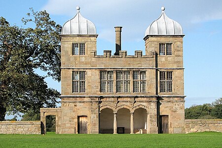
Swarkestone Hall Pavilion, also known as Swarkestone Stand and The Grandstand, is a 17th-century pavilion 200 metres north of the ruins of Swarkestone Hall, Swarkestone, Derbyshire. It is a Grade I listed building south of Chellaston on the A514. The pavilion was constructed between 1630 and 1632. Its frontage displays the arms of Sir John Harpur and his wife Catherine Howard (granddaughter of the Earl of Suffolk), who had married in 1631 or 1632, so it may have been built in celebration of their marriage. The Harpur family lived at the adjacent Swarkestone (Old) Hall, built in the 1560s for Sir Richard Harpur.The purpose of the building is a matter of some debate. It has been referred to as the Bowling Alley House, The Stand, The Grandstand, The Bullring and The Summerhouse; it is also suggested it may be a banqueting house or a decorative part of a formal garden. Even the enclosure to the front of the pavilion is debated, with suggestions it may have been constructed in the 19th century when the Swarkestone estate was used for large-scale livestock breeding.

Excerpt from the Wikipedia article Swarkestone Hall Pavilion (License: CC BY-SA 3.0, Authors, Images).

Swarkestone Hall Pavilion
A514, South Derbyshire

Geographical coordinates (GPS) Address Website External links Nearby Places
placeShow on map

Wikipedia: Swarkestone Hall PavilionContinue reading on Wikipedia

Geographical coordinates (GPS)

Latitude Longitude
N 52.854 ° E -1.445 °
placeShow on map

Address

Swarkestone Pavilion

A514
DE73 7JB South Derbyshire
England, United Kingdom
mapOpen on Google Maps

Website
landmarktrust.org.uk

linkVisit website

linkWikiData (Q7653876)
linkOpenStreetMap (277887247)

Swarkestone Hall Pavilion 1
Share experience

Nearby Places

Shelton Lock
Shelton Lock

Shelton Lock is a suburb in the south of the city of Derby, Derbyshire, England, located between Chellaston and Allenton. The area gets its name from the lock on the Derby Canal that once ran through the area. The only traces of the canal's existence are seen in the form of a road bridge, the lock stones, and a cycle path which covers it. The canal was shut in the 1960s but there are plans to re-excavate it. The site of Fullen's Lock is located just a few hundred yards along the present-day cycle path from Shelton Lock bridge, and a children's playground close to the site still bears the name. Merrill College is the local secondary school. It was located on Jubilee Road but was demolished – the new Merrill College is in Allenton (the old Thomas Moore school). The area also has an infant and junior school. Chellaston Road is the main road through the area, where a lot of inter-war private housing can be found. The George V Jubilee Estate was built in 1935 to commemorate King George V's silver jubilee and this lies to the west of Jubilee Road. St Edmund’s Church on Sinfin Avenue by the Derby architect Arthur Eaton was opened in 1939. The Sinfin Avenue estate was built in the 1970s, and includes a number of council and private houses. To the rear of the estate are fields and woodland, which are part of Sinfin Moor – as well as the disused railway which goes towards Chellaston. Significant areas of these fields and woodland have now been built on forming the Bonnie Prince housing estate. A spur of the M64 motorway was planned to pass through this area towards the Rolls-Royce works. This was never built and the route was instead used for the A50 road; Shelton Lock is connected to this by the A514.