Laurel Springs Ranch
Buildings and structures in Santa Barbara County, CaliforniaGeography of Santa Barbara County, CaliforniaRanches in California

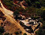
Laurel Springs Ranch is a 160-acre (0.65 km2) ranch located on a ridgetop in the Santa Ynez Mountain range northwest of Santa Barbara, California, between the Painted Cave community and the intersection of Painted Cave road with East Camino Cielo Road in the Los Padres National Forest.
Excerpt from the Wikipedia article Laurel Springs Ranch (License: CC BY-SA 3.0, Authors, Images).Laurel Springs Ranch
Painted Cave Road,
Geographical coordinates (GPS) Address Nearby Places Show on map
Geographical coordinates (GPS)
| Latitude | Longitude |
|---|---|
| N 34.5059 ° | E -119.7949 ° |
Address
Painted Cave Road 2720 B
93111
California, United States
Open on Google Maps


