Abu Ghosh
16th-century establishments in Ottoman SyriaAbu GhoshAll accuracy disputesArab localities in IsraelCanaanite cities ... and 5 more
HummusIngush diasporaLocal councils in Jerusalem DistrictTegart fortsThrone villages

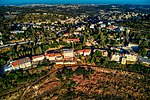
Abu Ghosh (Arabic: أبو غوش; Hebrew: אבו גוש) is an Arab-Israeli local council in Israel, located 10 kilometers (6 mi) west of Jerusalem on the Tel Aviv–Jerusalem highway. It is situated 610–720 meters above sea level. It takes its current name from the dominant clan inhabiting the town, while the older Arabic name used to be Qaryat al-'Inab (Arabic: قرية العنب, lit. 'Grape Village').
Excerpt from the Wikipedia article Abu Ghosh (License: CC BY-SA 3.0, Authors, Images).Abu Ghosh
Hashikune,
Geographical coordinates (GPS) Address Nearby Places Show on map
Geographical coordinates (GPS)
| Latitude | Longitude |
|---|---|
| N 31.804722222222 ° | E 35.110833333333 ° |
Address
هشيكون
Hashikune
Jerusalem District, Israel
Open on Google Maps


