Rivière de l'Est
Rivers of FranceRivers of RéunionRéunion geography stubs

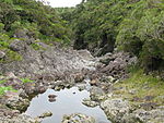
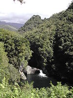
The Rivière de l'Est is a river on the Indian Ocean island of Réunion. It flows northeast from the southeast of the island, reaching the sea between the towns of Sainte-Anne and Sainte-Rose. It is 21.2 km (13.2 mi) long.The Rivière de l'Est flows down the slopes of the Shield volcano Piton de la Fournaise from an elevation of 720 metres (2,350 ft) above sea level.
Excerpt from the Wikipedia article Rivière de l'Est (License: CC BY-SA 3.0, Authors, Images).Rivière de l'Est
Chemin Robespierre, Saint-Benoît
Geographical coordinates (GPS) Address Nearby Places Show on map
 Continue reading on Wikipedia
 Geographical coordinates (GPS)
| Latitude | Longitude |
|---|---|
| N -21.106111111111 ° | E 55.770277777778 ° |
Address
Chemin Robespierre
Chemin Robespierre
Saint-Benoît
Réunion, France
Open on Google Maps