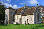
St Leonard's Church in Berwick St Leonard, Wiltshire, England, was built in the 12th century. It is recorded in the National Heritage List for England as a designated Grade II* listed building, and is now a redundant church in the care of the Churches Conservation Trust. It was declared redundant on 22 June 1973, and was vested in the Trust on 9 June 1976.The manor was held in the 12th century by Shaftesbury Abbey's manor of Tisbury. At that time there was no right of burial at Berwick, and bodies were taken to Tisbury. The right of advowson was later held by a variety of individuals, and there was a dispute over the right between John Benett and John Maclntyre, an East India Company general during the early 19th century.The small church was built of flint and limestone, in the 12th century. The three bay nave is 33 feet 6 inches (10.21 m) by 16 feet 4 inches (4.98 m), while the chancel is just 18 feet 9 inches (5.72 m) long and 13 feet 3 inches (4.04 m) wide. The entrance is beneath the small two-stage south tower which was added in the 14th century, and is supported by diagonal buttresses. The tower holds two bells dating from 1725 and 1766. The church roof is tiled in a fish-scale pattern. Monuments inside the church include those to George Howe, who died in 1647, and his six children. The cylindrical stone font with a brass cover, the lintel over the blocked north doorway, and a sculptured relief of the Lamb of God over the inside of the south doorway date from the Norman era.By the 19th century the fabric of the building was decaying, and it was rebuilt in 1860 with little change to its external appearance, at the expense of Alfred Morrison of Fonthill Gifford. The church was closed in 1966.


