Treasure Island, San Francisco
1930s establishments in CaliforniaAll pages needing factual verificationArtificial islands of CaliforniaCalifornia Historical LandmarksGolden Gate International Exposition ... and 15 more
Historic American Buildings Survey in CaliforniaHistoric American Engineering Record in CaliforniaIslands of Northern CaliforniaIslands of San FranciscoIslands of San Francisco BayLandmarks in San FranciscoNeighborhoods in San FranciscoParks in San FranciscoStrategic Air Command radar stationsTreasure Island, San FranciscoUnited States automatic tracking radar stationsUse mdy dates from February 2014Vague or ambiguous time from October 2012Vague or ambiguous time from October 2013Works Progress Administration in California

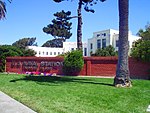
Treasure Island is an artificial island in the San Francisco Bay and a neighborhood in the City and County of San Francisco. Built in 1936–37 for the 1939 Golden Gate International Exposition, the island's World's Fair site is a California Historical Landmark. Buildings there have been listed on the National Register of Historic Places, and the historical Naval Station Treasure Island, an auxiliary air facility (for airships, blimps, dirigibles, planes and seaplanes), are designated in the Geographic Names Information System.
Excerpt from the Wikipedia article Treasure Island, San Francisco (License: CC BY-SA 3.0, Authors, Images).Treasure Island, San Francisco
9th Street, San Francisco
Geographical coordinates (GPS) Address Nearby Places Show on map
Geographical coordinates (GPS)
| Latitude | Longitude |
|---|---|
| N 37.825 ° | E -122.371 ° |
Address
9th Street & Avenue H
9th Street
94130 San Francisco
California, United States
Open on Google Maps


