Barbary Coast Trail

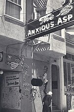
The Barbary Coast Trail is a marked trail that connects a series of historic sites and several local history museums in San Francisco, California. Approximately 180 bronze medallions and arrows embedded in the sidewalk mark the 3.8-mile (6.1 km) trail. The historic sites of the Barbary Coast Trail relate primarily to the period from the California Gold Rush of 1849 to the Earthquake and Fire of 1906, a period when San Francisco grew from a small village to an important shipping port. Sites along the trail include the Old Mint, a national historic landmark; Union Square; Maiden Lane; Old St. Mary's Cathedral, first Catholic cathedral West of the Rockies; T'ien Hou temple, one of the oldest still-operating Chinese temples in the United States; Wells Fargo History Museum; Pony Express headquarters site; Jackson Square Historic District, which contains the last cluster of Gold Rush and Barbary Coast-era buildings in San Francisco; The Old Ship Saloon, once a shanghaiing den; Coit Tower; Fisherman's Wharf; SF Maritime National Historical Park, which maintains a large collection of historic ships; and Ghirardelli Square. Each end of the Barbary Coast Trail is connected by the Hyde-Powell cable car line, itself a national historic landmark.
Excerpt from the Wikipedia article Barbary Coast Trail (License: CC BY-SA 3.0, Authors, Images).Barbary Coast Trail
Columbus Avenue, San Francisco
Geographical coordinates (GPS) Address Nearby Places Show on map
Geographical coordinates (GPS)
| Latitude | Longitude |
|---|---|
| N 37.799444444444 ° | E -122.40888888889 ° |
Address
Bank of the West
Columbus Avenue 480
94113 San Francisco
California, United States
Open on Google Maps


