place

Ehrenbreitstein Fortress
Buildings and structures in KoblenzCastles in Rhineland-PalatinateLandmarks in GermanyMuseums in Rhineland-PalatinateTourist attractions in Rhineland-Palatinate
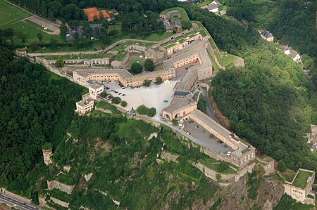
Festung Ehrenbreitstein Luftbild 080

Ehrenbreitstein Fortress (German: Festung Ehrenbreitstein, IPA: [ˌfɛstʊŋ ˈeːʁənbʁaɪtʃtaɪn] (listen)) is a fortress in the German state of Rhineland-Palatinate, on the east bank of the Rhine where it is joined by the Moselle, overlooking the town of Koblenz. Occupying the position of an earlier fortress destroyed by the French in 1801, it was built as the backbone of the regional fortification system, Festung Koblenz, by Prussia between 1817 and 1828 and guarded the middle Rhine region, an area that had been invaded by French troops repeatedly before. The Prussian fortress was never attacked. Since 2002, Ehrenbreitstein has been part of the UNESCO World Heritage Site Upper Middle Rhine Valley.

Excerpt from the Wikipedia article Ehrenbreitstein Fortress (License: CC BY-SA 3.0, Authors, Images).

Ehrenbreitstein Fortress
Hofstraße, Koblenz Ehrenbreitstein

Geographical coordinates (GPS) Address Website External links Nearby Places
placeShow on map

Wikipedia: Ehrenbreitstein FortressContinue reading on Wikipedia

Geographical coordinates (GPS)

Latitude Longitude
N 50.365 ° E 7.6152777777778 °
placeShow on map

Address

Festung Ehrenbreitstein

Hofstraße
56077 Koblenz, Ehrenbreitstein
Rhineland-Palatinate, Germany
mapOpen on Google Maps

Website
tor-zum-welterbe.de

linkVisit website

linkWikiData (Q50712)
linkOpenStreetMap (658556277)

Festung Ehrenbreitstein Luftbild 080
Share experience

Nearby Places

Middle Rhine
Middle Rhine

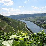
Between Bingen and Bonn, Germany, the river Rhine flows as the Middle Rhine (German: Mittelrhein, pronounced [ˈmɪtl̩ˌʁaɪn] (listen)) through the Rhine Gorge, a formation created by erosion, which happened at about the same rate as an uplift in the region, leaving the river at about its original level, and the surrounding lands raised. This gorge is quite deep, about 130 metres (430 ft) from the top of the rocks down to the average water-line. The "Middle Rhine" is one of four sections (High Rhine, Upper Rhine, Middle Rhine, Lower Rhine) of the river between Lake Constance and the North Sea. The upper half of the Middle Rhine (Rhine Gorge) from Bingen (Rhine-kilometer 526) to Koblenz (Rhine-kilometer 593) is a UNESCO World Heritage Site as a striking cultural landscape with more than 40 castles and fortresses from the Middle Ages, unique terraced vineyards, and many wine-villages. The lower half from Koblenz (Rhine-kilometer 593) to Bonn (Rhine-kilometer 655) is famous for the formerly volcanic Siebengebirge with the Drachenfels volcano. Both parts together are known as "the romantic Rhine". The Middle Rhine Valley has been a major tourist attraction since the 19th century. It is also home to some 450,000 people. The valley owes its special appearance to both its natural shape and human alterations. For two millennia, it has been one of the most important routes for cultural exchange between the Mediterranean region and northern Europe. Situated in the heart of Europe, it was sometimes a border and sometimes a bridge between different cultures. The history of the valley reflects the history of Western Europe. With its many outstanding monuments, its hills full of vines, its settlements crowded on the narrow river banks, and the rows of castles lined up on the hill tops, it is considered the epitome of the Rhine romanticism. It inspired Heinrich Heine to write his famous poem "Lorelei" and Richard Wagner to write his opera Götterdämmerung. The vineyards along the Middle Rhine form the wine-growing region of the same name, see Mittelrhein (wine region).

Rhine Province
Rhine Province

The Rhine Province (German: Rheinprovinz), also known as Rhenish Prussia (Rheinpreußen) or synonymous with the Rhineland (Rheinland), was the westernmost province of the Kingdom of Prussia and the Free State of Prussia, within the German Reich, from 1822 to 1946. It was created from the provinces of the Lower Rhine and Jülich-Cleves-Berg. Its capital was Koblenz and in 1939 it had 8 million inhabitants. The Province of Hohenzollern was militarily associated with the Oberpräsident of the Rhine Province. The Rhine Province was bounded on the north by the Netherlands, on the east by the Prussian provinces of Westphalia and Hesse-Nassau, and the grand duchy of Hesse-Darmstadt, on the southeast by the Palatinate (a district of the Kingdom of Bavaria), on the south and southwest by Lorraine, and on the west by Luxembourg, Belgium and the Netherlands. The small exclave district of Wetzlar, wedged between the grand duchy states Hesse-Nassau and Hesse-Darmstadt was also part of the Rhine Province. The principality of Birkenfeld, on the other hand, was an enclave of the Grand Duchy of Oldenburg, a separate state of the German Empire. In 1911, the extent of the province was 10,423 km2 (4,024 sq mi); its extreme length, from north to south, was nearly 200 km (120 mi), and its greatest breadth was just under 90 km (56 mi). It included about 200 km (120 mi) of the course of the Rhine, which formed the eastern border of the province from Bingen to Koblenz, and then flows in a north-northwesterly direction inside the province, approximately following its eastern border. It is now part of North Rhine-Westphalia, Rhineland-Palatinate, Saarland, and Hesse.