Ings, Cumbria
AC with 0 elementsCumbria geography stubsSouth Lakeland DistrictUse British English from September 2019Villages in Cumbria

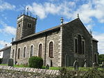
Ings is a village in the South Lakeland district of Cumbria, England. It lies on the course on the River Gowan and A591 road, 2 miles (3.2 km) east of Windermere.Ings is located in the parish of Hugill, historically a part of Westmorland. The Grade II*-listed St Anne's Church is located within the village.
Excerpt from the Wikipedia article Ings, Cumbria (License: CC BY-SA 3.0, Authors, Images).Ings, Cumbria
A591, South Lakeland Hugill
Geographical coordinates (GPS) Address Website Nearby Places Show on map
Geographical coordinates (GPS)
| Latitude | Longitude |
|---|---|
| N 54.3792 ° | E -2.8537 ° |
Address
Lakeland Vintners
A591
LA8 9PY South Lakeland, Hugill
England, United Kingdom
Open on Google Maps


