place

Piers Island

British Columbia Coast geography stubsIslands of the Gulf IslandsUse Canadian English from January 2023
Piers Island
Piers Island

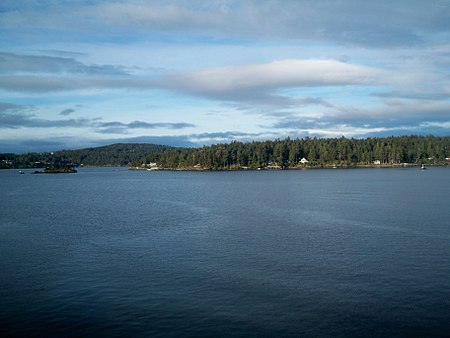
Piers Island is a small island in Satellite Channel, British Columbia, Canada. The channel joins Saanich Inlet on the west with Colburne Passage to Haro Strait on the east, which is the section of the Canada–US border separating the Gulf Islands in British Columbia, of which Piers is a part, from the San Juan Islands of Washington state. Haro Strait is part of the Inside Passage from Washington to Alaska through which ships can find waters relatively sheltered from Pacific Ocean waves and storms for most of its length. Piers Island is separated from the somewhat larger Portland Island by Shute Passage to the northeast.

Excerpt from the Wikipedia article Piers Island (License: CC BY-SA 3.0, Authors, Images).

Piers Island
McKenzie Crescent, Southern Gulf Islands Electoral Area

Geographical coordinates (GPS) Address Nearby Places
placeShow on map

Wikipedia: Piers IslandContinue reading on Wikipedia

Geographical coordinates (GPS)

Latitude Longitude
N 48.7 ° E -123.41666666667 °
placeShow on map

Address

McKenzie Crescent
V8L 5J4 Southern Gulf Islands Electoral Area
British Columbia, Canada
mapOpen on Google Maps

Piers Island
Piers Island
Share experience

Nearby Places

Sidney, British Columbia

Sidney is a town located at the northern end of the Saanich Peninsula, on Vancouver Island in the province of British Columbia. It's 1 of the 13 Greater Victoria municipalities. It has a population of approximately 11,583. Sidney is located just east of Victoria International Airport, and about 6 km (4 mi) south of BC Ferries' Swartz Bay Terminal. The town is also the only Canadian port-of-call in the Washington State Ferries system, with ferries running from Sidney to the San Juan Islands and Anacortes. Sidney is located along Highway 17, which bisects the town from north to south. It is generally considered part of the Victoria metropolitan area. The town west of Highway 17 (also called Patricia Bay Highway, locally abbreviated as the Pat Bay Highway) has a mixture of single-family residences and light industry. The majority of the town is located east of Highway 17. Single-family units are also present east of the highway, but the eastern sector also has many condominium-type buildings, plus most of the service and retail outlets. The island-studded Haro Strait, part of the Salish Sea, forms Sidney's eastern boundary. There is a large boating and marine industry in the area, ranging from marinas to boatbuilders and marine suppliers. Sidney takes its name from nearby Sidney Island. In 1859, Captain Richards named that island for Frederick W. Sidney, who, like Richards served in the survey branch of the Royal Navy.: 243