place

Carfax Conduit

1617 establishments in EnglandAqueducts in EnglandBuildings and structures completed in 1617Buildings and structures in OxfordshireEnglish Heritage sites in Oxfordshire
Grade II* listed buildings in OxfordshireGrade I listed buildings in OxfordshireInfrastructure completed in 1617Scheduled monuments in OxfordshireUse British English from March 2017
Carfax Conduit building

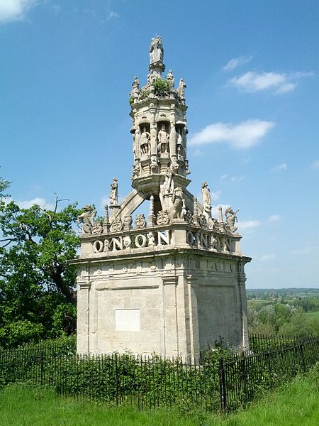
The Carfax Conduit was a water conduit that supplied the city of Oxford with water from 1610 until 1869. The conduit ran in an underground lead pipe from a spring on the hillside above the village of North Hinksey, beneath Seacourt Stream and the River Thames, to a building at Carfax in the centre of Oxford. The system was built by Otho Nicholson, a London lawyer, to supply the citizens of Oxford with clean water. It replaced a system built by Osney Abbey between 1205 and 1221 that had fallen into disrepair.The conduit building at Carfax was an elaborate structure, some 40 feet (12 m) tall, with eight niches containing statues of historic and mythical figures. By 1787 it had become an obstacle to traffic and it was removed in 1797 and replaced by a smaller cistern. The original structure was given to the Earl Harcourt, who had it re-erected in the grounds of his home, Nuneham House, where it remains to this day. Two plaques are attached to opposite sides of the building, giving a short history in English and Latin. The re-erected conduit is a Grade I listed building and scheduled monument.A building, now called the Conduit House, was built at Harcourt Hill over the spring. It remains in situ and is in the care of English Heritage. The Conduit House site is designated as a Grade II* listed building and a scheduled monument.The entire system fell into disuse in the 19th century. In 1869, when it was carrying very little water, the conduit was sold to Oxford Corporation.

Excerpt from the Wikipedia article Carfax Conduit (License: CC BY-SA 3.0, Authors, Images).

Carfax Conduit
Thame Lane, South Oxfordshire Nuneham Courtenay

Geographical coordinates (GPS) Address External links Nearby Places
placeShow on map

Wikipedia: Carfax ConduitContinue reading on Wikipedia

Geographical coordinates (GPS)

Latitude Longitude
N 51.6752 ° E -1.2244 °
placeShow on map

Address

Carfax Conduit

Thame Lane
OX14 3ES South Oxfordshire, Nuneham Courtenay
England, United Kingdom
mapOpen on Google Maps

linkWikiData (Q5039236)
linkOpenStreetMap (556961815)

Carfax Conduit building
Share experience

Nearby Places

Joint European Torus

The Joint European Torus (JET) was a magnetically confined plasma physics experiment, located at Culham Centre for Fusion Energy in Oxfordshire, UK. Based on a tokamak design, the fusion research facility was a joint European project with a main purpose of opening the way to future nuclear fusion grid energy. At the time of its design JET was larger than any comparable machine. JET was built with the hope of reaching scientific breakeven where the fusion energy gain factor Q =1.0. It began operation in 1983 and spent most of the next decade increasing its performance in a lengthy series of experiments and upgrades. In 1991 the first experiments including tritium were made, making JET the first reactor in the world to run on the production fuel of a 50–50 mix of tritium and deuterium. It was also decided to add a divertor design to JET, which occurred between 1991 and 1993. Performance was significantly improved, and in 1997 JET set the record for the closest approach to scientific breakeven, reaching Q = 0.67 in 1997, producing 16 MW of fusion power while injecting 24 MW of thermal power to heat the fuel.Between 2009 and 2011, JET was shut down to rebuild many of its parts, to adopt concepts being used in the development of the ITER project in Saint-Paul-lès-Durance, in Provence, southern France. In December 2020, a JET upgrade commenced using tritium, as part of its contribution to ITER. On 21 December 2021, using deuterium-tritium fuel, JET produced 59 megajoules during a five-second pulse, beating its previous 1997 record of 21.7 megajoules, with Q = 0.33.In November 2023, a petition asking that JET not be closed was started, with scientists fearing a research time gap and personnel loss between JET's closure and the start of ITER's operations. JET finished operations in December 2023, with decommissioning expected to last until 2040.

RNAS Culham (HMS Hornbill)

Royal Naval Air Station Culham (RNAS Culham, also known as HMS Hornbill) was a former Royal Navy, Fleet Air Arm station near Culham, Oxfordshire. It opened in 1944 as an All Weather Airfield for the Royal Navy. The airbase was used by Receipt and Despatch Unit No.2, No.1 Ferry Flight, 739 Photographic Trials and Development Unit and home to 1832 R.N.V.R. (Air) Squadron.The airbase is situated around 5 miles (8.0 km) south of the city of Oxford, with the village of Culham lying 1 mile (1.6 km) to west. The notable landmarks include the city of Oxford where through it runs The Isis, which then forms a loop around the airfield to the north, west and south as it flows south east. The market town of Abingdon-on-Thames is about 2 miles (3.2 km) to the north west. Didcot junction, where a line running north/south, intersects the Great Western Main Line, is situated 3 miles (4.8 km) south, with Culham railway station, on the north/south Oxford-Didcot line, at the south west corner of the airfield.The ground layout was typical of many bomber stations, with three runways. However it had many hangars, mostly sited around the field's perimeter. Initially HMS Hornbill was used to train reservists based in the Thames Valley area using several different types of aircraft including: Supermarine Seafire, a navalised Supermarine Spitfire fighter aircraft, Hawker Sea Fury, a single-seat fighter aircraft and North American Harvards, an American single-engine advanced trainer aircraft. In May 1947 the Photographic Trials and Development Unit was based at HMS Hornbill, and in 1951 1840 Naval Air Squadron operated from the airfield for a short time. Ab initio flight training of cadets from Britannia Royal Naval College, Dartmouth, flying primary gliders, was also undertaken here in the early 1950s.

Abingdon Junction railway station

Abingdon Junction railway station was a junction station for the branch line to Abingdon. It was opened by the Abingdon Railway Company on 2 June 1856 along with the branch, and was subsequently closed and replaced by Radley railway station on 8 September 1873. Radley station was in a more convenient place for access. At the same time as the station's opening, the next station to the south, formerly known as Abingdon Road was renamed Culham.In 1837 the first Bill for a railway to Abingdon was laid before Parliament; it would have brought a direct line from Didcot to Oxford through the town. The House of Commons passed the Bill, but the Lords rejected it. The Bill for the Oxford line was revived in the following year, but so strong was the opposition of Mr. Duffield, Abingdon's M.P., that the proposed line was forced to by-pass Abingdon; it eventually opened on 12 June 1844 and ran no nearer to Abingdon than the village of Radley, some two miles to the east.Located at the point where the branch diverges from the main line, Abingdon Junction was provided purely for interchange for services to Oxford, Culham and Didcot and was not shown in timetables. No proper road access to the station was provided and only modest passenger facilities were afforded consisting of two facing wooden platforms with a small building constructed on the up main side and a run-around loop for branch services and connections with the main line.Following the conversion of the branch to standard gauge in November 1872, works began to extend the line a further ¾ mile northwards alongside the main line to reach a new station at Radley where it terminated in a bay platform on the station's west side. The station building from Abingdon Junction was transported to Radley, where it was sited just south of the road bridge, most likely on the down side. It remained there until well into British Railways days and was used by gangers and platelayers. The remains of Abingdon Junction survived for several years before their demolition, so that the only trace of the station today is the widened formation to the west of the main line before the Abingdon branch curved away.