Bad Dürkheim (district)
Anterior PalatinateBad Dürkheim (district)Districts of Rhineland-PalatinatePages with German IPA
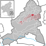
Bad Dürkheim (German pronunciation: [ˌbaːt ˈdʏʁkhaɪm]) is a district in Rhineland-Palatinate, Germany. It is bounded by (from the west and clockwise) the districts of Kaiserslautern, Donnersbergkreis and Alzey-Worms, the city of Worms, the Rhein-Pfalz-Kreis, the city of Neustadt/Weinstraße, the districts of Südliche Weinstraße, the city of Landau (the Taubensuhl/Fassendeich forest part of the city), the district Südwestpfalz, and the city of Kaiserslautern.
Excerpt from the Wikipedia article Bad Dürkheim (district) (License: CC BY-SA 3.0, Authors).Bad Dürkheim (district)
Felsenbergweg,
Geographical coordinates (GPS) Address Nearby Places Show on map
Geographical coordinates (GPS)
| Latitude | Longitude |
|---|---|
| N 49.5 ° | E 8.17 ° |
Address
Felsenbergweg
67098
Rhineland-Palatinate, Germany
Open on Google Maps


