City Square, Leeds
Squares in LeedsUse British English from January 2019

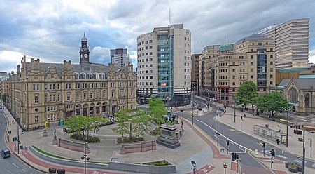
City Square is a paved area north of Leeds railway station at the junction of Park Row to the east and Wellington Street to the south. It is a triangular area where six roads meet: Infirmary Street and Park Row to the north, Boar Lane and Bishopsgate Street to the south-east, and Quebec Street and Wellington Street to the south-west. The only building with a direct frontage is the former General Post Office, on the north-west side.
Excerpt from the Wikipedia article City Square, Leeds (License: CC BY-SA 3.0, Authors, Images).City Square, Leeds
City Square, Leeds Holbeck Urban Village
Geographical coordinates (GPS) Address External links Nearby Places Show on map
Geographical coordinates (GPS)
| Latitude | Longitude |
|---|---|
| N 53.7964 ° | E -1.5476 ° |
Address
City Square
City Square
Leeds, Holbeck Urban Village
England, United Kingdom
Open on Google Maps


