place

Turgo

Mount MerapiMountains of IndonesiaSleman Regency
Turgo from Plawangan

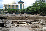
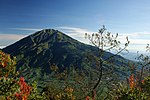
Turgo is a small basaltic hill on the southern slopes of Mount Merapi, Indonesia, and is also known as Gunung Turgo or Mount Turgo. It is administratively located in Purwobinangun, Pakem, Sleman Regency, Special Region of Yogyakarta. Recent work suggests that the hill itself is older than the present volcanic cone of Gunung Merapi. It is just west of Plawangan, the valley between the two has been subject to nuée ardente in the 1990s which killed local villagers. Despite the very small area on the peak of Turgo, it has some sacred graves that are attributed to be connected with Sheikh Jumadil Qubro, a direct descendant of the Islamic prophet, Muhammad, and as consequence is considered to be part of the complex network of graves that constitute the Javanese sacred places Dutch anthropologist Martin van Bruinessen has written about this character following his residence in Yogyakarta.It is also located within the solukhambu nature reserve, a 200 ha (490-acre) nature reserve on the slope of Merapi that has rare animals and plants occurring in its area.

Excerpt from the Wikipedia article Turgo (License: CC BY-SA 3.0, Authors, Images).

Geographical coordinates (GPS)

Latitude Longitude
N -7.5840277777778 ° E 110.42386111111 °
placeShow on map

Address


55583 Purwobinangun
Special Region of Yogyakarta, Indonesia
mapOpen on Google Maps

Turgo from Plawangan
Share experience

Nearby Places

Mount Merapi
Mount Merapi

Mount Merapi, Gunung Merapi (literally Fire Mountain in Indonesian and Javanese), is an active stratovolcano located on the border between the province of Central Java and the Special Region of Yogyakarta, Indonesia. It is the most active volcano in Indonesia and has erupted regularly since 1548. It is located approximately 28 km (17 mi) north of Yogyakarta city which has a population of 2.4 million, and thousands of people live on the flanks of the volcano, with villages as high as 1,700 m (5,577 ft) above sea level. Smoke can often be seen emerging from the mountaintop, and several eruptions have caused fatalities. A pyroclastic flow from a large explosion killed 27 people on 22 November 1994, mostly in the town of Muntilan, west of the volcano. Another large eruption occurred in 2006, shortly before the Yogyakarta earthquake. In light of the hazards that Merapi poses to populated areas, it was designated as one of the Decade Volcanoes. On the afternoon of 25 October 2010, Merapi erupted on its southern and southeastern slopes. A total of 353 people were killed over the next month, while 350,000 were forced to flee their homes; most of the damage was done by pyroclastic flows, while heavy rain on 4 November created lahars which caused further damage. Most of the fissures had ceased erupting by 30 November, and four days later the official threat level was lowered. Merapi's characteristic shape was changed during the eruptions, with its height lowered 38 m (125 ft) to 2,930 m (9,613 ft).Since 2010, Merapi had experienced several smaller eruptions, most noticeably two phreatic eruptions which occurred on 18 November 2013 and 11 May 2018. The first and larger of these, caused by a combination of rainfall and internal activity, saw smoke issued up to a height of 2,000 m (6,562 ft). There have been several small eruptions since the beginning of 2020, which are of great interest to volcanologists.

Mount Merbabu
Mount Merbabu

Mount Merbabu (Indonesian: Gunung Merbabu) is a dormant stratovolcano in Central Java province on the Indonesian island of Java. The name Merbabu could be loosely translated as 'Mountain of Ash' from the Javanese combined words; Meru means "mountain" and awu or abu means "ash". The active volcano Mount Merapi is directly adjacent on its south-east side, while the city of Salatiga is located on its northern foothills. A 1,500m high broad saddle lies between Merbabu and Merapi, the site of the village of Selo, Java and highly fertile farming land. There are two peaks; Syarif (3,119 m) and Kenteng Songo (3,145 m). Three U-shaped radial valleys extend from the Kenteng Songo summit in northwesterly, northeastly and southeastly directions. Two known moderate eruptions occurred in 1560 and 1797. The 1797 event was rated 2: Explosive, on the Volcanic Explosivity Index. An unconfirmed eruption may have occurred in 1570.Geologically recent eruptions originated from a North Northwest-South Southeast fissure system that cut across the summit and fed the large-volume lava flows from Kopeng and Kajor craters on the northern and southern flanks, respectively.Merbabu can be climbed from several routes originating from the town of Kopeng on the north east sideside, and also from Selo on the southern side. A climb from Kopeng to Kenteng Songo takes between 8 and 10 hours.An area of 57 km² at the mountain has been declared a national park in 2004.