place

The Fort (Morrison, Colorado)

1963 establishments in ColoradoBuildings and structures in Jefferson County, ColoradoColorado Registered Historic Place stubsColorado building and structure stubsCommercial buildings on the National Register of Historic Places in Colorado
National Register of Historic Places in Jefferson County, ColoradoPueblo Revival architecture in ColoradoRestaurants established in 1963Restaurants in ColoradoRestaurants on the National Register of Historic PlacesTourist attractions in Jefferson County, ColoradoUnited States restaurant stubsUse mdy dates from August 2023
The fort
The fort

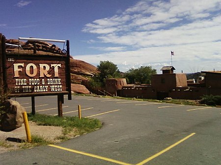
The Fort is a historic restaurant in Morrison, Colorado. The structure was inspired by Bent's Fort.In 1997 the restaurant hosted President Bill Clinton’s state dinner for the 23rd G8 summit.

Excerpt from the Wikipedia article The Fort (Morrison, Colorado) (License: CC BY-SA 3.0, Authors, Images).

The Fort (Morrison, Colorado)
CO 8,

Geographical coordinates (GPS) Address External links Nearby Places
placeShow on map

Wikipedia: The Fort (Morrison, Colorado)Continue reading on Wikipedia

Geographical coordinates (GPS)

Latitude Longitude
N 39.628936111111 ° E -105.192525 °
placeShow on map

Address

The Fort

CO 8 19192
80465
Colorado, United States
mapOpen on Google Maps

linkWikiData (Q7734874)
linkOpenStreetMap (227720861)

The fort
The fort
Share experience

Nearby Places

Bradford House II
Bradford House II

Bradford House II (Site 5JF51) is a prehistoric rockshelter, 24 kilometres (15 mi) southwest of Denver. It is situated on land owned by the Ken-Caryl Ranch Master Association. It was excavated in the summer and fall of 1973 by the Denver Chapter of the Colorado Archaeological Society. The excavations found several cultural features and recovered thousands of chipped stone artifacts, dozens of ground stone artifacts, a few ceramic sherds, bone tools, and faunal remains. The site was used by prehistoric groups during the Middle and Late Archaic periods, as well as the Early Woodland, and Middle Woodland periods. This is a span of 4,500 years. Bradford House II is located in the Ken-Caryl Valley. The Front Range foothills to the west and the Lyons and Dakota hogbacks to the east frame the valley. An abundance of archaeological sites, attests to the valley's attraction for the earliest inhabitants of the area. They frequented the area for its abundant resources, including shelter under the many bedrock monoliths scattered across the valley, lithic materials for chipped stone tools, and edible plants and animals. West of the valley, the arkosic sandstones of the Pennsylvanian Fountain formation lie unconformably upon uplifted Precambrian metamorphic rocks of the Front Range (Rathbun 1997:21) . Although mostly covered by recent to pre-Wisconsin alluvium, the Fountain formation forms southwest facing escarpments, or monoliths, with undercut shelters or caves (Rathbun 1997:21), many of which were inhabited by prehistoric peoples. The elevation of the site is approximately 1878 m (6160 ft.) above mean sea level. Elevations surrounding the site range from about 1828 m (6000 ft.) in the Dutch Creek water gap to 1992 m (6536 ft.) on the highest point of the Dakota hogback ridge. The valley has a sunny, mild, and semiarid climate that has neither the extreme cold of the higher elevations to the west nor the hot summer afternoons of the eastern plains (Tate 1997:15). A south-facing rock shelter like Bradford House II absorbs a great deal of solar radiation, further mitigating the winter cold. Precipitation is moderate, averaging 15 to 18 inches, and winter snows melt quickly (Tate 1997:17) with frequent down slope (chinook) winds. The valley consists of various grasses and forbs. The surrounding hogbacks and foothills support a pine-Douglas fir vegetation community. The recovery of floral materials from Bradford House II and other archaeological sites in the valley (Johnson 1997:Table Gl) indicates that local plants such as sunflower, wild plum, acorn, and chokecherry were gathered and used by prehistoric peoples. Many animals, including elk, mule deer, and occasional Big Horn sheep, as well as a variety of carnivores, rabbits, rodents, birds, amphibians, reptiles, and fish are found in the hogbacks and foothills. Unworked animal, mostly mammal, bone was found in abundance in the Archaic and Early Ceramic levels (Johnson and Lyons 1997a:49, Table 6). Mule deer dominates the assemblage, followed by elk, bison, and rabbit, with little change in dietary preferences from the earlier to later time periods. Several bone tools (awls, beads, reamers, bone scrapers, and bone drills) and antler flakers were recovered from all cultural levels in the site (Johnson and Lyons 1997a) .
Red Rocks Park
Red Rocks Park

Red Rocks Park is a mountain park in Jefferson County, Colorado, owned and maintained by the city of Denver as part of the Denver Mountain Parks system. The park is known for its very large red sandstone outcrops. Many of these rock formations within the park have names, from the mushroom-shaped Seat of Pluto to the inclined Cave of the Seven Ladders. The most visited rocks, around Red Rocks Amphitheatre, are Creation Rock to the north, Ship Rock to the south, and Stage Rock to the east. The red sandstone found throughout Red Rocks Park is geologically identified as belonging to the Fountain Formation. Other Colorado examples of Fountain Formation geology include nearby Roxborough State Park, Garden of the Gods near Colorado Springs, and the Flatirons near Boulder. The rocks were formed about 290-296 million years ago when the Ancestral Rocky Mountains were eroded during the Pennsylvanian epoch. Later, uplift during the Laramide orogeny tilted the rocks to the angle at which they sit today. An Army expedition led by Stephen Long discovered present-day Red Rocks in 1820. The park was in times far past a favored campsite of the Ute tribe for it provided natural cover from the elements. Its earliest known name was the Garden of the Angels, reputedly given to it on July 4, 1870, by Martin Van Buren Luther, a pioneer Colorado judge. In 1872, Marion Burts became the first recorded owner of Red Rocks. He sold it to Leonard H. Eicholtz, a civil engineer who helped build the Union Pacific Railway and who developed the property into a park in 1878. Eicholtz added roads, trails, picnic grounds, steps, and ladders so visitors could explore the park. In 1906, Eicholtz sold Red Rocks to famed editor John Brisben Walker which he purchased with proceeds from his sale of Cosmopolitan magazine; Walker organized concerts on a temporary platform at the Garden of the Titans. Known however by the folk name of Red Rocks since the area was settled, it was formally given that name when Denver acquired it in 1928 from Walker. Within the park boundaries is the Red Rocks Amphitheatre, a venue used since 1941. The Amphitheater was designed by Burnam Hoyt within the area between two massive slabs of Red stone (Ship Rock and Creation Rock).

Red Rocks Amphitheatre

Red Rocks Amphitheatre (also colloquially as simply Red Rocks) is an open-air amphitheatre built into a rock structure in the western United States, near Morrison, Colorado, ten miles (16 km) west of Denver. There is a large, tilted, disc-shaped rock behind the stage, a huge vertical rock angled outwards from stage right, several large outcrops angled outwards from stage left and a seating area for up to 9,525.In 1927, the City of Denver purchased the area of Red Rocks; construction of the amphitheater began in 1936, and was opened to the public in June 1941. Since then, many notable performances and recordings for film and television have taken place there. In June 2015, the Colorado Music Hall of Fame opened in the Trading Post at Red Rocks.The elevation of the amphitheatre's top row is approximately 6,450 feet (1,965 m) above sea level, and the surrounding Red Rocks Park covers 868 acres (1.4 sq mi; 3.5 km2). The amphitheater is owned and operated by the City and County of Denver and is located in Red Rocks Park, part of the Denver Mountain Parks. The audience faces east-northeast, toward southern Denver, with the skyline of downtown visible to the left. In 1957, the American Institute of Architects selected Red Rocks to be Colorado's entry at the National Gallery of Art for the AIA's Centennial Exhibition. In 1999, after Pollstar magazine awarded Red Rocks the annual honor of being the best small outdoor venue for the eleventh time, the magazine changed the name of the award to the Red Rocks Award and removed Red Rocks from the running.Construction began in October 2020 to replace the existing stage roof and structure.