place

Monolith Festival

Accuracy disputes from March 2022Music festivals in ColoradoRock festivals in the United StatesTourist attractions in Jefferson County, Colorado

The Monolith Festival was a music festival held at Red Rocks Amphitheatre in Morrison, Colorado. The first festival took place September 14–15, 2007 on 5 stages, including the Red Rocks main stage.The 2008 Monolith Festival was held on September 13–14. On April 11, 2009, it was announced on the official Monolith Festival Facebook Page that the 2009 Monolith Festival will be held on September 12–13.

Excerpt from the Wikipedia article Monolith Festival (License: CC BY-SA 3.0, Authors).

Monolith Festival
Trading Post Road,

Geographical coordinates (GPS) Address Nearby Places
placeShow on map

Wikipedia: Monolith FestivalContinue reading on Wikipedia

Geographical coordinates (GPS)

Latitude Longitude
N 39.66555 ° E -105.20523 °
placeShow on map

Address

Trading Post Road
80465
Colorado, United States
mapOpen on Google Maps

Share experience

Nearby Places

Red Rocks Amphitheatre

Red Rocks Amphitheatre (also colloquially as simply Red Rocks) is an open-air amphitheatre built into a rock structure in the western United States, near Morrison, Colorado, ten miles (16 km) west of Denver. There is a large, tilted, disc-shaped rock behind the stage, a huge vertical rock angled outwards from stage right, several large outcrops angled outwards from stage left and a seating area for up to 9,525.In 1927, the City of Denver purchased the area of Red Rocks; construction of the amphitheater began in 1936, and was opened to the public in June 1941. Since then, many notable performances and recordings for film and television have taken place there. In June 2015, the Colorado Music Hall of Fame opened in the Trading Post at Red Rocks.The elevation of the amphitheatre's top row is approximately 6,450 feet (1,965 m) above sea level, and the surrounding Red Rocks Park covers 868 acres (1.4 sq mi; 3.5 km2). The amphitheater is owned and operated by the City and County of Denver and is located in Red Rocks Park, part of the Denver Mountain Parks. The audience faces east-northeast, toward southern Denver, with the skyline of downtown visible to the left. In 1957, the American Institute of Architects selected Red Rocks to be Colorado's entry at the National Gallery of Art for the AIA's Centennial Exhibition. In 1999, after Pollstar magazine awarded Red Rocks the annual honor of being the best small outdoor venue for the eleventh time, the magazine changed the name of the award to the Red Rocks Award and removed Red Rocks from the running.Construction began in October 2020 to replace the existing stage roof and structure.

Red Rocks Park
Red Rocks Park

Red Rocks Park is a mountain park in Jefferson County, Colorado, owned and maintained by the city of Denver as part of the Denver Mountain Parks system. The park is known for its very large red sandstone outcrops. Many of these rock formations within the park have names, from the mushroom-shaped Seat of Pluto to the inclined Cave of the Seven Ladders. The most visited rocks, around Red Rocks Amphitheatre, are Creation Rock to the north, Ship Rock to the south, and Stage Rock to the east. The red sandstone found throughout Red Rocks Park is geologically identified as belonging to the Fountain Formation. Other Colorado examples of Fountain Formation geology include nearby Roxborough State Park, Garden of the Gods near Colorado Springs, and the Flatirons near Boulder. The rocks were formed about 290-296 million years ago when the Ancestral Rocky Mountains were eroded during the Pennsylvanian epoch. Later, uplift during the Laramide orogeny tilted the rocks to the angle at which they sit today. An Army expedition led by Stephen Long discovered present-day Red Rocks in 1820. The park was in times far past a favored campsite of the Ute tribe for it provided natural cover from the elements. Its earliest known name was the Garden of the Angels, reputedly given to it on July 4, 1870, by Martin Van Buren Luther, a pioneer Colorado judge. In 1872, Marion Burts became the first recorded owner of Red Rocks. He sold it to Leonard H. Eicholtz, a civil engineer who helped build the Union Pacific Railway and who developed the property into a park in 1878. Eicholtz added roads, trails, picnic grounds, steps, and ladders so visitors could explore the park. In 1906, Eicholtz sold Red Rocks to famed editor John Brisben Walker which he purchased with proceeds from his sale of Cosmopolitan magazine; Walker organized concerts on a temporary platform at the Garden of the Titans. Known however by the folk name of Red Rocks since the area was settled, it was formally given that name when Denver acquired it in 1928 from Walker. Within the park boundaries is the Red Rocks Amphitheatre, a venue used since 1941. The Amphitheater was designed by Burnam Hoyt within the area between two massive slabs of Red stone (Ship Rock and Creation Rock).

Dinosaur Ridge
Dinosaur Ridge

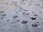
Dinosaur Ridge is a segment of the Dakota Hogback in the Morrison Fossil Area National Natural Landmark located in Jefferson County, Colorado, near the town of Morrison and just west of Denver. The Dinosaur Ridge area is one of the world's most famous dinosaur fossil localities. In 1877, fossil excavation began at Dinosaur Ridge under the direction of paleontologist Othniel Charles Marsh. Some of the best-known dinosaurs were found here, including Stegosaurus, Apatosaurus, Diplodocus, and Allosaurus. In 1973, the area was recognized for its uniqueness as well as its historical and scientific significance when it was designated the Morrison Fossil Area National Natural Landmark by the National Park Service. In 1989, the Friends of Dinosaur Ridge formed to address increasing concerns regarding the preservation of the site and to offer educational programs on the area's resources. The rocks on the west side of Dinosaur Ridge are part of the widespread Morrison Formation of Jurassic age. It is in these rocks, where Arthur Lakes discovered the dinosaur bones in 1877. Fifteen quarries were opened along the Dakota hogback in the Morrison area in search of these fossils. The rocks on the east side of Dinosaur Ridge are part of the Cretaceous Dakota Formation. When Alameda Parkway was being constructed in 1937 to provide access to Red Rocks Park, workers discovered hundreds of dinosaur footprints. These were found to include mostly Iguanodon-like footprints, perhaps from Eolambia. Carnivorous theropod tracks are also present. The site features the Dinosaur Ridge Exhibit Hall with displays about the dinosaurs found at the site. Additionally, Dinosaur Ridge has interpretive signs at trail locations that explain the local geology, a volcanic ash bed, trace fossils, paleo-ecology, economic development of coal, oil and clay, and many other geologic and paleontological features. In June 2011, Dinosaur Ridge was combined with another track site, the Parfet Prehistoric Preserve, about three miles north. The combined National Natural Landmark is now the Morrisson-Golden Fossil Areas.

Dakota Hogback
Dakota Hogback

The Dakota Hogback is a long hogback ridge at the eastern fringe of the Rocky Mountains that extends north-south from southern Wyoming through Colorado and into northern New Mexico in the United States. The ridge is prominently visible as the first line of foothills along the edge of the Great Plains. It is generally faulted along its western side, and varies in height, with gaps in numerous locations where rivers exit the mountains. The ridge takes its name from the Dakota Formation, a formation with resistant sandstone beds that cap the ridge. The hogback was formed during the Laramide orogeny, approximately 50 million years (50 my) ago, when the modern Rockies were created. The general uplift to the west created long faulting in the North American Plate, resulting in the creation of the hogback.While the hogback was created during the Laramide Orogeny, the geologic strata comprising the hogback are much older. For example, fossilized data such as dinosaur footprints have been observed in the exposed strata, created by dinosaurs which lived during the Jurassic Period approximately 150 million years ago. Some of these footprints were attributed to the Diplodocus dinosaur and could be seen on the hogback west of Denver, Colorado as recently as the 1980s.The ridge forms a barrier between the high plains and the Rocky Mountain foothills. The ridge is pierced by a few water-cut gaps, which have been used to provide road access between the mountains and the plains. The ridge is paralleled by I-25 from north of Cheyenne, Wyoming, through Colorado, into northern New Mexico. The ridge is to the west. North of Denver its major gaps are I-80 in southern Wyoming, U.S. Highway 34 at Loveland, and U.S. 36 to Rocky Mountain National Park. Interstate 70 passes through a highway cut, revealing the numerous layers making up the ridge. South of Denver, the major gaps are U.S. Route 24 in Colorado Springs, U.S. Route 50 in Pueblo, and finally in Colorado, U.S. Route 160 in Walsenburg.