Ząb, Lesser Poland Voivodeship
Lesser Poland geography stubsVillages in Tatra County

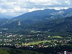
Ząb [zɔmp] (until 1965 Zubsuche) is a village in the administrative district of Gmina Poronin, within Tatra County, Lesser Poland Voivodeship, in southern Poland. It lies approximately 5 kilometres (3 mi) west of Poronin, 5 km (3 mi) north of Zakopane, and 81 km (50 mi) south of the regional capital Kraków.It is Poland's highest village by elevation, at 1,013 metres (3,323 ft) above sea level.
Excerpt from the Wikipedia article Ząb, Lesser Poland Voivodeship (License: CC BY-SA 3.0, Authors, Images).Ząb, Lesser Poland Voivodeship
Szlak Papieski, gmina Poronin
Geographical coordinates (GPS) Address Phone number Nearby Places Show on map
Geographical coordinates (GPS)
| Latitude | Longitude |
|---|---|
| N 49.336111111111 ° | E 19.9475 ° |
Address
Pokoje u Gromadów
Szlak Papieski 151
34-521 gmina Poronin
Lesser Poland Voivodeship, Poland
Open on Google Maps


