Plymouth Breakwater
BreakwatersBuildings and structures in Plymouth, DevonIndustrial archaeological sites in DevonLighthouses of the English ChannelSea forts

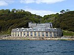
Plymouth Breakwater is a 1,560-metre (1,710 yd) stone breakwater protecting Plymouth Sound and the anchorages near Plymouth, Devon, England. It is 13 metres (43 ft) wide at the top and the base is 65 metres (213 ft). It lies in about 10 metres (33 ft) of water. Around 4 million tons of rock were used in its construction in 1812 at the then-colossal cost of £1.5 million (equivalent to £106 million today).
Excerpt from the Wikipedia article Plymouth Breakwater (License: CC BY-SA 3.0, Authors, Images).Plymouth Breakwater
Grand Parade, Plymouth West Hoe
Geographical coordinates (GPS) Address Nearby Places Show on map
Geographical coordinates (GPS)
| Latitude | Longitude |
|---|---|
| N 50.334161111111 ° | E -4.1486611111111 ° |
Address
Plymouth Breakwater Fort
Grand Parade
PL1 3DQ Plymouth, West Hoe
England, United Kingdom
Open on Google Maps


