Rangemore

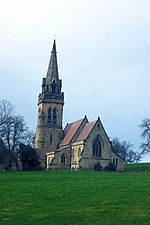
Rangemore is a village in the borough of East Staffordshire, situated approximately 4 miles (6 km) west of the town of Burton upon Trent, on a ridge of high ground about a mile due west of the village of Tatenhill where the population from the 2011 census can be found. Rangemore is in Needwood Forest, which is part of the National Forest. The Church of England parish church of All Saints belongs to the Diocese of Lichfield. The Grade II* church was designed by the Gothic Revival architect William Butterfield for Michael Thomas Bass and built in 1866–67. The chancel was designed by G.F. Bodley and added in 1895. The National Football Centre (NFC) of the England National Team received planning permission and funding from the Football Association in late 2010 to develop the nearby Byrkley Lodge site.
Excerpt from the Wikipedia article Rangemore (License: CC BY-SA 3.0, Authors, Images).Rangemore
East Staffordshire Tatenhill
Geographical coordinates (GPS) Address Nearby Places Show on map
Geographical coordinates (GPS)
| Latitude | Longitude |
|---|---|
| N 52.8 ° | E -1.74 ° |
Address
DE13 9RE East Staffordshire, Tatenhill
England, United Kingdom
Open on Google Maps


