Q and R Holes

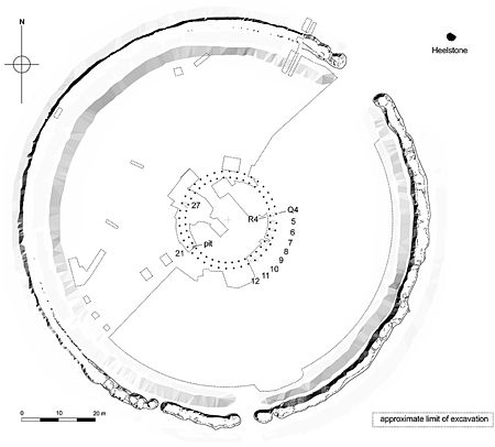
The Q and R Holes are a series of concentric sockets which currently represent the earliest known evidence for a stone structure on the site of Stonehenge. Beneath the turf and just inside the later Sarsen Circle is a double arc of buried stoneholes, the only surviving evidence of the first stone structure (possibly a double stone circle) erected within the centre of Stonehenge (Figs.1 & 2) and currently regarded as instigating the period known as Stonehenge Phase 3i. This phase may have begun as early as 2600 BC, although recent radiocarbon dates from samples retrieved from one of the sockets in 2008 during excavations by Darvill and Wainwright suggest a date of around 2400 to 2300 BC. They made a partial excavation of Q Hole 13, where 'associations with Beaker pottery' were noted.Although first encountered by William Hawley in the 1920s, it was Richard Atkinson who formally identified and named these irregular settings in 1954: "In choosing this designation, I had in mind John Aubrey’s frequent use, as a marginal note…of the phrase 'quaere quot' – 'inquire how many' – which seemed appropriate to the occasion". Their place at the beginning of the stone monument phase has been recognized from their stratigraphic relationships: in places they were cut through by both the settings of the later and still partly surviving Bluestone Circle, and also by a stonehole dug for one of the uprights of the Sarsen Circle.
Excerpt from the Wikipedia article Q and R Holes (License: CC BY-SA 3.0, Authors, Images).Q and R Holes
A303,
Geographical coordinates (GPS) Address Phone number Website Nearby Places Show on map
Geographical coordinates (GPS)
| Latitude | Longitude |
|---|---|
| N 51.178844444444 ° | E -1.8261888888889 ° |
Address
Stonehenge
A303
SP4 7DE , Amesbury
England, United Kingdom
Open on Google Maps


