Salt Creek (Orange County)

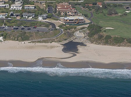
Salt Creek is a small coastal stream in southern Orange County in the U.S. state of California. The 4-mile (6.4 km) creek drains 6.1 square miles (16 km2) in parts of the cities of Laguna Niguel, Dana Point, and San Juan Capistrano. The mostly channelized creek has no named surface tributaries. The creek begins in the central portion of the city of Laguna Niguel and flows west and south through a narrow canyon referred to as the Salt Creek Corridor, which is mostly inside a long and narrow regional park. It then flows into the Monarch Beach Golf Course in the city of Dana Point and enters a subsurface storm channel ("Arroyo Salada Storm Channel") which carries it to its discharge point at Salt Creek County Beach.
Excerpt from the Wikipedia article Salt Creek (Orange County) (License: CC BY-SA 3.0, Authors, Images).Salt Creek (Orange County)
Monarch Bay Drive,
Geographical coordinates (GPS) Address Nearby Places Show on map
Geographical coordinates (GPS)
| Latitude | Longitude |
|---|---|
| N 33.481388888889 ° | E -117.72527777778 ° |
Address
Monarch Bay Drive
92629
California, United States
Open on Google Maps


