place

Skutz Falls

British Columbia Coast geography stubsCowichan Land DistrictCowichan ValleyWaterfalls of British Columbia

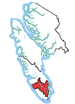
Skutz Falls is a waterfall on the Cowichan River on Vancouver Island, British Columbia, Canada. It is located just above Marie Canyon. The name was originally Skwets or Squitz, meaning "waterfall" in the Cowichan dialect of Halkomelem. When salmon are spawning, people come to the falls to see them climb up the fish ladders that were built beside the falls. Prior to the building of the fish ladder, the falls, which resemble steep rapids dropping about 20 feet, were a barrier for all fish. In the summer, the river is very calm below the falls and people visit the area to swim or inner tube below the falls. There is also a campground nearby.

Excerpt from the Wikipedia article Skutz Falls (License: CC BY-SA 3.0, Authors).

Skutz Falls
Mayo Road, Area F (Cowichan Lake South / Skutz Falls)

Geographical coordinates (GPS) Address Nearby Places
placeShow on map

Wikipedia: Skutz FallsContinue reading on Wikipedia

Geographical coordinates (GPS)

Latitude Longitude
N 48.783333333333 ° E -123.95 °
placeShow on map

Address

Mayo Road 5891
Area F (Cowichan Lake South / Skutz Falls)
British Columbia, Canada
mapOpen on Google Maps

Share experience

Nearby Places

Mesachie Lake

Mesachie Lake is an unincorporated community in the Cowichan Valley region of Vancouver Island, British Columbia, Canada. It lies on the south shore of Cowichan Lake, British Columbia. The name is from the Chinook Jargon for "bad, evil, naughty". It was founded in 1942 by the Hillcrest Lumber Company, which built houses for its workers and their families. This company also planted many non-native fruit and shade trees which have since been given heritage status. In 1942, houses from Sahtlam were cut into pieces and shipped via rail cars and then reassembled in Mesachie Lake with most houses there today having at least part of the original houses still being used. The mill was completely new in design, with more efficient modern equipment. The powerhouse was completed and the generators installed. The powerhouse was able to produce enough power not only for the mill and the community, but on occasion supplied the village of Lake Cowichan when its own plant was overloaded or broken down. In 1982, Camp Imadene bought the old Hillcrest site and moved their camp in a decade later. Mesachie Lake is still a vibrant community, although the school and church have been moved to Lake Cowichan. The Mesachie Skydome is home to many ball tournaments. The community hall hosts various events throughout the year. The town has its own post office and public boat launch. The original Hillcrest Lumber Company office is now a private residence, along with all of the houses once owned by workers at the mill. Mesachie Lake is also one of several towns in the Cowichan Valley with significant South Asian Canadian (primarily Sikh-Canadian) community history for over 130 years, gaining notoriety in the forestry industry at local sawmills from the early 20th century until the 1980s.

Koksilah Ridge
Koksilah Ridge

Koksilah Ridge (Hwsalu'utsum) is an elevated area located south of the Cowichan Valley on Vancouver Island, British Columbia. It is centered at 48°42′N, 123°47′W. Its summit lies about 892 meters (2,927 feet) above sea level. It is visible in most of the Cowichan Valley and on the Saanich Peninsula north of Brentwood Bay. As seen from North Saanich or Sidney, it is plough-shaped, with long gentle slopes. From north to south, the bedrock lithology begins with Cretaceous-era sedimentary rock, chiefly shale, sandstone and conglomerate. These sediments extend up to about 250–500 meters (820–1,640 ft). Above them lies a pluton of Jurassic-age granodiorite, which underlies the summit. Around the eastern, southern and western edges of this pluton is a complex association of Pennsylvanian-era argillite, greywacke, chert and diabase. The soils of Koksilah Ridge are well or rapidly drained gravelly sandy loams and gravelly loamy sands with podzol profile development. They support Coastal Western Hemlock-type forests in which Douglas-fir and western hemlock are most common at lower elevations. These forests are classified under the provincial Biogeoclimactic Ecosystem Classification as Coastal Western Hemlock, Very Dry Maritime Subzone (CWHxm2). Areas above 700 meters (2,300 feet) are mapped as Coastal Western Hemlock, Moist Maritime Subzone (CWHmm2), with abundant Douglas-fir, amabilis fir, and western hemlock.The forest industry has been active on Koksilah Ridge for many years and the native forest is interrupted by logged-off areas of varying size. These clear cuts are prominent when a snow cover is present. Snow may lie on the higher parts for up to six months over a severe winter, but is seen on only a few days through a mild winter. Island Timberlands presently has tenure.