place

Los Angeles Airways Flight 841
1968 in Los AngelesAccidents and incidents involving the Sikorsky S-61Airliner accidents and incidents caused by mechanical failureAirliner accidents and incidents in CaliforniaAviation accident stubs
Aviation accidents and incidents in the United States in 1968Disasters in Los AngelesLos Angeles Airways accidents and incidentsMay 1968 events in the United StatesParamount, California
6308 340DisneyLandChopper R

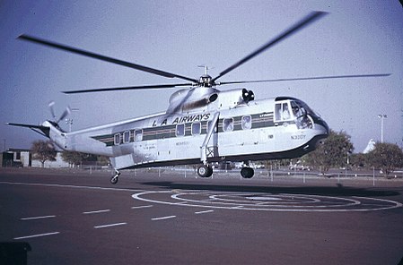
Los Angeles Airways Flight 841 was a Sikorsky S-61 helicopter that crashed at 5:50 p.m. on Wednesday, May 22, 1968, in the city of Paramount, California. All twenty passengers and three crew members were killed. The aircraft was destroyed by impact and fire. The probable cause of the accident was a mechanical failure in the blade rotor system, which then allowed one blade to strike the side of the fuselage. The other four blades were then thrown out of balance and all five rotor blades broke and then the rear fuselage and tail separated from the rest of the airframe. The cause of the mechanical failure is undetermined. At the time, it was the worst helicopter-related accident in U.S. aviation history, not to be surpassed until the 1986 Grand Canyon mid-air collision which killed 25. Los Angeles Airways (LAA) Flight 841 was a regularly scheduled passenger flight from Disneyland Heliport in Anaheim, California to Los Angeles International Airport. The flight was westbound at 2,000 feet over Paramount, California when air traffic controllers received a distress message from pilots: "L.A., we're crashing, help us." The helicopter crashed onto a dairy farm and burst into flames. N303Y, a Sikorsky S-61L helicopter, serial number 61060, had accumulated 12,096 total flying hours prior to the accident. Much of the debris was contained in the dairy farm where the helicopter crashed. The tail rotor was discovered one block east of the crash site in a used truck yard. Among those killed was a group of nine vacationers from Ohio; a Hunt-Wesson Foods executive; the mayor of Red Bluff, California; and a University of California, Berkeley professor.

Excerpt from the Wikipedia article Los Angeles Airways Flight 841 (License: CC BY-SA 3.0, Authors, Images).

Los Angeles Airways Flight 841
Alondra Boulevard,

Geographical coordinates (GPS) Address Nearby Places
placeShow on map

Wikipedia: Los Angeles Airways Flight 841Continue reading on Wikipedia

Geographical coordinates (GPS)

Latitude Longitude
N 33.8888 ° E -118.1671 °
placeShow on map

Address

Alondra Boulevard

Alondra Boulevard
90638
California, United States
mapOpen on Google Maps

6308 340DisneyLandChopper R
Share experience

Nearby Places

Hay Tree
Hay Tree

Hay Tree is a historic camphor tree in what is now downtown Paramount, California. The Hay Tree was designated a California Historic Landmark (No. 1038) on August 8, 2003. The tree is one of the newest California Historic Landmark. At the time of planting in 1883 the tree was in the town of Hynes. The towns of Hynes and Clearwater incorporated to the town of Paramount in 1948. Paramount officially incorporated on January 30, 1957. The Hay Tree is now 50 foot high and surround by a small grass park. The Hay Tree the only reminder of the area's busy hay and dairy industry. From 1930 to 1960 the towns of Hyne and Clearwater were known as the “Hay Capital” of the world. The area was also known as “The Milk Shed of Los Angeles” and “The World’s Largest Hay Market.” These titles were given for the vast hay fields and dairy farms in the area. There were over 25,000 milk cows in the towns of Hynes and Clearwater at this time. The price of the Hay on the commodity market was set each morning at the Hay Tree. In the 1960s and 1970s the region slowly became an urban area. House and stores replaced milk production. Many of the dairy farms moved to the city of Ontario, California and Chino, California. But the Hay Tree remained. The Hay Tree has both a California State Marker and a city education display. The site also has benches and wooden cow display. The Hay Tree is at the entrance to Paramount Civic center. A local artist wrote and performed a song about the tree.

North Long Beach, Long Beach, California

North Long Beach (also referred to as North Town or Northside) is a predominantly working-class area of Long Beach, California. The neighborhood is bounded to the west, north and east by the Long Beach city limits (the Rancho Dominguez unincorporated county area and the cities of Compton, Paramount, Bellflower and Lakewood), and to the south by a Union Pacific railroad track and the Bixby Knolls neighborhood. The north boundary with Paramount is only a few blocks north of the Artesia Freeway (California State Route 91). North Long Beach is mostly residential. It is home to the Uptown Business Improvement District, which represents commercial and multifarious property owners on Atlantic Avenue between Artesia Blvd and Market Street and a portion of Artesia Blvd adjacent to Jordan High School, as well as retail activity along most major streets in the area, including Artesia Boulevard, Long Beach Boulevard, and Cherry Avenue. There are some industrial businesses, mostly along the eastern edge of North Long Beach between Cherry Avenue and Paramount Boulevard, serviced by the Union Pacific Railroad. The northern end of the district is home to Houghton Park, the Michelle Obama Neighborhood Library, Fire Station 12, and Jordan High School, while the southern end includes the Carmelitos housing project and its adjacent small shopping center. On its west side, at approximately Market Street and Long Beach Boulevard, is the site of the original Long Beach civic center dating back to the city's rancho days. The Long Beach Police Department's North Division operates a substation on the corner of Atlantic and Del Amo, at Scherer Park. According to 2021 U.S. Census estimates, the neighborhood was home to over 93,000 people (roughly one-fifth of the total population of the city). Roughly 69% of the population was Hispanic, roughly 28% were black, roughly 0.9% were non-Hispanic whites, and roughly 1% were Asian.