place

Sola, Norway

1930 establishments in NorwayJærenMunicipalities of RogalandPages with non-numeric formatnum argumentsSeaside resorts in Norway
Sola, Norway
Beach of Sola
Beach of Sola

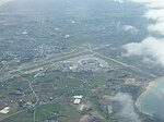
Sola is a municipality and a Seaside resort in Rogaland county, Norway. It is located in the traditional district of Jæren. The administrative centre of the municipality is the village of Solakrossen. Other villages include Tananger, Hålandsmarka, Sørnes, and Stenebyen. Stavanger Airport is located in Sola, just a short distance from the large Stavanger/Sandnes metropolitan area. The 69-square-kilometre (27 sq mi) municipality is the 342nd largest by area out of the 356 municipalities in Norway. Sola is the 41st most populous municipality in Norway with a population of 28,315. The municipality's population density is 411.4 inhabitants per square kilometre (1,066/sq mi) and its population has increased by 15.2f% over the previous 10-year period. In the western part of Sola, there are 5 kilometres (3.1 mi) of long, sandy beaches facing the North Sea. With usually ample supplies of wind and waves, the sandy beaches are a popular place for windsurfing.

Excerpt from the Wikipedia article Sola, Norway (License: CC BY-SA 3.0, Authors, Images).

Sola, Norway
To taxi, Sola

Geographical coordinates (GPS) Address Nearby Places
placeShow on map

Wikipedia: Sola, NorwayContinue reading on Wikipedia

Geographical coordinates (GPS)

Latitude Longitude
N 58.88 ° E 5.6286111111111 °
placeShow on map

Address

To taxi
4055 Sola
Norway
mapOpen on Google Maps

Beach of Sola
Beach of Sola
Share experience

Nearby Places

Ytraberget
Ytraberget

Ytraberget is a small peninsula that sticks out into the Hafrsfjord in the municipality of Sola in Rogaland county, Norway. Ytraberget is connected to Indraberget and it is located, just north of the village of Sørnes, between two small bays: Sørnesvågen and Grannesvågen. Harald Fairhair (ca. 865-ca. 933) fought the Battle of Hafrsfjord during 872 AD. In the Saga by Snorri Sturluson, a little isle is mentioned as the location where Kjotve the Rich fled the battle. The little isle is commonly held to have been Ytraberget, although it is now connected by a low isthmus of some 2 metres (6 ft 7 in) in elevation to Indraberget. It is thought that the Earth's crust rebounding post glaciation over 1,100 years has exposed the connection between the two. On the top of the hill, there is a plateau about 100 by 50 metres (330 ft × 160 ft). This is the area of the Bronze Age stone fortifications (bygdeborg). There are three or four buildings that were a part of the ruined structure, all about 8 by 5 metres (26 ft × 16 ft). Near the top of Ytraberget there is a stone slab monument erected in 1972 near the ruins for the 1,100-year anniversary of the Battle of Hafrsfjord. There are good fishing and swimming possibilities at Ytraberget. Ytraberget today is a very common swimming spot for local teenagers.Indraberget is the mainland area that Ytreberget connects to. This area has some of the richest limestone flora in this part of Norway. There is also rich archeological findings for the Stone Age, Bronze Age and to modern times.

Hafrsfjord
Hafrsfjord

Hafrsfjord or Hafrsfjorden is a fjord in the Stavanger Peninsula in Rogaland county, Norway. The 9-kilometre (5.6 mi) long fjord forms the border between the municipalities of Stavanger and Sola. On the west side of the fjord is the large village of Tananger, on the south is the village of Solakrossen, and on the east end of the fjord is the borough of Madla in the city of Stavanger. The Møllebukta bay area, located on the innermost part of the fjord, is the site of a popular beach and the Sverd i Fjell statues. The only bridge over the fjord is the Hafrsfjord Bridge which runs between Kvernevik in Stavanger and Jåsund in the village of Tananger in Sola. Hafrsfjord is also the name of a neighbourhood (delområde) in the borough of Madla in the city of Stavanger. It has a population of 4,003, distributed on an area of 5.78 square kilometres (2.23 sq mi). Hafrsfjord is also the location of the KNM Harald Hårfagre, the Basic Training Establishment for the Royal Norwegian Navy. The camp had been used for military purposes since 1871 and in 1934 it was renamed Madlaleiren. In 1952, Parliament decided that the Navy's boot camp would be added to the camp and also that the Navy would formally take over the camp. Three years later, the camp was named KNM Harald Hårfagre. Today KNM Harald Hårfagre is the principal training camp for both the Royal Navy and Royal Air Force. Officer Candidate School for the Navy moved the intake and basic education from Horten to KNM Harald Hårfagre during the summer of 2005.