place

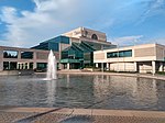
Sir Guy Carleton Secondary School

High schools in Ottawa

Sir Guy Carleton Secondary School is a secondary school in Ottawa, Ontario, Canada. The school specializes in Skilled Trades Education, with three Specialist High Skills Majors (SHSM) programs. It is an application based school serving students living in the west side of the Ottawa Carleton District School Board. The school also has three OCDSB Specialized Special Education Classes: a General Learning Program, a Physical Support Program and a Behavioural Intervention Program. Offer of placements in the Special Education Classes is done by central board committee. The school is located in Nepean on Centrepointe Drive. Sir Guy is under the jurisdiction of the Ottawa Carleton District School Board. Sir Guy is also known for their motto The School That Works; it is well-known not for its athletics but is for its classes.

Excerpt from the Wikipedia article Sir Guy Carleton Secondary School (License: CC BY-SA 3.0, Authors).

Sir Guy Carleton Secondary School
Centrepointe Drive, Ottawa Nepean

Geographical coordinates (GPS) Address Nearby Places
placeShow on map

Wikipedia: Sir Guy Carleton Secondary SchoolContinue reading on Wikipedia

Geographical coordinates (GPS)

Latitude Longitude
N 45.346733 ° E -75.765152 °
placeShow on map

Address

Centrepointe Drive 55
K2G 5L4 Ottawa, Nepean
Ontario, Canada
mapOpen on Google Maps

Share experience

Nearby Places

Centrepointe
Centrepointe

Centrepointe is a neighbourhood in College Ward in the west end of the city of Ottawa, Ontario, Canada. It was formerly part of the city of Nepean. It is a newer residential subdivision in the west/central part of Ottawa, developed from 1984 onwards, and is informally bounded by Baseline Road to the north, Woodroffe Avenue to the east, the CN railroad to the south, and the Briargreen subdivision and Forest Ridge Apartments to the west. The housing stock includes approximately 1,000 detached homes, with the remainder mostly townhomes (row houses) and terrace homes. According to the Canada 2016 Census, the neighbourhood had a total population of 7,245. Previously farmland, it was purchased by the Canada Mortgage and Housing Corporation, which let the land lay fallow for many years. It had been intended to be developed as a demonstration model of an "ideal community". After facing budget cuts, CMHC sold the land, with most being sold off to Ottawa's largest housing developer Minto Group, which built and sold off a wide range of homes from townhouses to large upscale houses. The neighbourhood was built to be Nepean's "downtown", with plans to build shops and offices and a civic square, to house Nepean's city hall. The neighbourhood was built as a "self-contained community" and was projected to cost $700 million.Its major attraction is Ben Franklin Place, named for the former mayor of Nepean, which houses the Centrepointe Branch of the Ottawa Public Library, the locally renowned Centrepointe Theatre, and the former Nepean City Hall (now housing satellite offices for the City of Ottawa). The neighbourhood has a significant Jewish population. The 2011 National Household Survey indicated that 13% of the neighbourhood's population was Jewish.The Centrepointe Community Association was formed on February 4, 2006 to represent and advance the interests of neighbourhood residents. A major issue confronting the association is the City of Ottawa's proposed development of the Centrepointe Town Centre concept, which could add up to two million square feet of high density residential and commercial space to the area. Residential construction in Centrepointe continues. In 2007, a former snow dump next to Centrepointe Park was converted into approximately 260 townhouses, terrace homes and low-rise apartments, which was completed in early 2011. The Centrepointe Community Association has not been very active as of late; however, it does advertise a community garage sale each spring. The easternmost portion of Centrepointe underwent major development. As of January 2012, construction had finished on three major projects: the City of Ottawa Archives at the corner of Tallwood Drive and Woodroffe Avenue, a new trades building for nearby Algonquin College, and expansion of Centrepointe Theatre at Ben Franklin Place. Baseline Station Portions of Constellation Drive were rerouted to accommodate the new buildings and as part of the City's long-term public transportation plan. As of 2022, two major apartment building projects are underway in the north section of Centrepointe: a 2-tower (22 and 24 storeys) Richcraft condominium complex on the southwest corner at 19 Centrepointe Drive, and a 15-storey rental apartment building near the northeast corner of Constellation Drive (2140 Baseline Road). Baseline station is expected to be the terminus of Stage 2 of the LRT's Confederation Line, to be completed in 2023.Many school-aged children attend Briargreen, Manordale, Knoxdale (French Immersion), Greenbank Middle School (closed in 2017), and then Sir Robert Borden High School.

Nepean, Ontario
Nepean, Ontario

Nepean ( nə-PEE-ən) is a former municipality and now geographic area of Ottawa, Ontario, Canada. Located west of Ottawa's inner core, it was an independent city until amalgamated with the Regional Municipality of Ottawa–Carleton in 2001 to become the new city of Ottawa. However, the name Nepean continues in common usage in reference to the area. The population of Nepean is about 186,593 people (2021 Census). Although the neighbouring municipality of Kanata formed the entrepreneurial and high tech centre of the region, Nepean hosted noted industries such as Nortel Networks, JDS Uniphase and Gandalf Technologies. As with the rest of the National Capital Region, however, Nepean's economy was also heavily dependent on federal government employment. Most of Nepean's employed residents commute to downtown Ottawa or Kanata for work.Nepean's policies of operational and capital budgeting prudence contrasted with the budget philosophies of some other municipalities in the area. Nepean instituted a strict 'pay-as-you-go' budgeting scheme. The city entered amalgamation with a large surplus and a record of tax restraint. However, most big-ticket municipal infrastructure items (transit, garbage collection, sanitary sewers, water, arterial roads, social services) were the responsibility of the Regional Municipality of Ottawa-Carleton. It maintained its own library system from 1954 to amalgamation, its own police force from 1964 until it was regionalized in the 1990s; its own fire service and its own recreation programs. Hydro services were the responsibility of the Hydro-Electric Commission of the City of Nepean (commonly referred to as Nepean Hydro). Education in the City of Nepean was provided by the Carleton Board of Education (later amalgamated with the Ottawa Board of Education to form the Ottawa-Carleton District School Board). Prior to amalgamation, Nepean's City Council spent many tax dollars aggressively campaigning against what they (and their allies) referred to as the "megacity" model. The central plank of the strategy was to promote a tri-city model, which would have seen the ten municipalities of the Ottawa region reduced to three: one in the west (comprising Nepean, Kanata and the western rural municipalities), one in the east (comprising Gloucester, Cumberland and the eastern rural municipalities) and one in the centre (comprising Ottawa, Vanier and Rockcliffe Park). These efforts were in vain, as the one-city model eventually prevailed. (The one-city model was recommended by Glen Shortliffe, who was appointed by the Government of Ontario to study the issue of municipal reform in Ottawa-Carleton.)

Parkway Park
Parkway Park

Parkway Park is a neighbourhood in College Ward in Ottawa, Ontario, Canada. It is bounded to the north by the Queensway, to the west by Cobden Road, to the south by Baseline Road and to the east by Pinecrest Creek and the OC Transpo Transitway. Developed during the late 1950s and early 1960s along with the nearby neighbourhoods of Kenson Park, Queensway Terrace North and South, Bel-Air Park and Ridgeview. The community is mostly middle class. In the Iris, Cobden and Elmira areas there are community housing projects. To the west of the projects is a small shopping strip on Cobden. Around Baseline, Highgate and Westbury there are three-story apartment buildings owned by Minto. Many Algonquin College students live there. Parkway Park is home to three schools: Terre-des-Jerres, Bishop Hamilton Montessori School and Joan D'Arc. Joan D'Arc is a girls private school (the school used to be Queensway Public School until its closure in 1999). Terre-des-Jerres recently moved from the former Whitehaven Public School location. The built used to be Des Laurier High School which moved the former J. S. Woodsworth Secondary School location on Chesteron and Viewmount Drive in Parkwood Hills. It is also home to the 2 parks, Parkway Park and Pinecrest Recreation Park with a baseball diamond. The Pinecrest Recreation Centre features meeting rooms, a gym, a swimming pool and a hockey arena a named after Canadian skater Barbara Ann Scott. Next to the arena there is a court named after Barbara Ann Scott with townhouses.