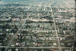
Crown Hill, Seattle

Crown Hill is a neighborhood in the city of Seattle, in the U.S. state of Washington. The neighborhood is bounded on the south by N.W. 85th Street, beyond which is Loyal Heights & Whittier Heights, followed by Ballard; on the east by 8th Avenue N.W., beyond which is Greenwood; on the north by NW 105th Street, beyond which are (from east to west) Broadview, Carkeek Park, and Blue Ridge, and on the west by 15th Avenue N.W., beyond which are (from east to west) Loyal Heights, Sunset Hill and Golden Gardens Park. It is part of the parcel of formerly unincorporated King County that was annexed by Seattle on January 4, 1954.The Crown Hill Cemetery is located in the neighborhood.
Excerpt from the Wikipedia article Crown Hill, Seattle (License: CC BY-SA 3.0, Authors, Images).Crown Hill, Seattle
13th Avenue Northwest, Seattle Greenwood
Geographical coordinates (GPS) Address Nearby Places Show on map
Geographical coordinates (GPS)
| Latitude | Longitude |
|---|---|
| N 47.695668 ° | E -122.372253 ° |
Address
13th Avenue Northwest 9044
98117 Seattle, Greenwood
Washington, United States
Open on Google Maps


