place

Frederick Douglass Square Historic District

Boston Registered Historic Place stubsHistoric districts in Suffolk County, MassachusettsHistoric districts on the National Register of Historic Places in MassachusettsNRHP infobox with nocatNational Register of Historic Places in Boston
Roxbury, BostonUse American English from November 2021Use mdy dates from November 2021
Frederick Douglass Square Roxbury MA 1

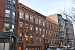
The Frederick Douglass Square Historic District is a historic district roughly bounded by Hammond Street, Cabot Street, Windsor Street, and Westminster Street, in the Lower Roxbury area of Boston, Massachusetts. It covers a 5-acre (2.0 ha) that is a remarkably well-preserved and cohesive residential development created as the result of one of Boston's many land-reclamation projects in the 19th century. This area, originally salt marshes that flooded at high tide, was at first gradually filled in as the Boston Neck was widened with the construction of Tremont Street and railroad lines. The Tremont Improvement Company acquired a remnant portion of the salt marshes by the early 1860s, and built a series of single-family row houses on the land that resulted from filling it in. The district includes most of the residential properties on Warwick, Greenwich, and Sussex Streets, as well as clusters of properties on adjacent streets.The district was added to the National Register of Historic Places in 1996 and is a pending Boston Landmark. The nearby intersection of Tremont and Hammond streets was dedicated as Frederick Douglass Square in 1917, giving the district its name.

Excerpt from the Wikipedia article Frederick Douglass Square Historic District (License: CC BY-SA 3.0, Authors, Images).

Frederick Douglass Square Historic District
Warwick Street, Boston South End

Geographical coordinates (GPS) Address Nearby Places
placeShow on map

Wikipedia: Frederick Douglass Square Historic DistrictContinue reading on Wikipedia

Geographical coordinates (GPS)

Latitude Longitude
N 42.335833333333 ° E -71.084444444444 °
placeShow on map

Address

Warwick Street 36
02199 Boston, South End
Massachusetts, United States
mapOpen on Google Maps

Frederick Douglass Square Roxbury MA 1
Share experience

Nearby Places

South End Grounds
South End Grounds

South End Grounds refers to any one of three baseball parks on one site in Boston, Massachusetts. They were home to the franchise that eventually became known as the Boston Braves, first in the National Association and later in the National League, from 1871 to 1914. At least in its third edition, the formal name of the park—as indicated by the sign over its entrance gate—was Boston National League Base Ball Park. It was located on the northeast corner of Columbus Avenue and Walpole Street (now Saint Cyprian's Place), just southwest of Carter Playground. Accordingly, it was also known over the years as Walpole Street Grounds; two other names were Union Base-ball Grounds and Boston Baseball Grounds. The ballpark was across the New York, New Haven and Hartford Railroad tracks, to the south, from the eventual site of the Huntington Avenue Grounds, home field of Boston's American League team prior to the building of Fenway Park. The Boston club was initially known as the "Red Stockings," because four of its key players had come from the famous 1869–1870 barnstorming team known as the Cincinnati Red Stockings and took the nickname with them to Boston. Over time the team acquired other informal nicknames, such as "Beaneaters," "Red Caps," "Rustlers" and "Doves." This team eventually adopted the official nickname "Braves," just a few years before abandoning South End Grounds. With its tight foul lines and expansive center field, like a scaled-down version of the Polo Grounds, it was sometimes said that the South End had no right or left field, only a center field. South End Grounds was rebuilt twice during its lifetime, the first time by choice and the second time by necessity.