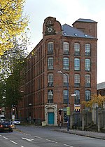
Radford, Nottingham
Areas of NottinghamFormer civil parishes in NottinghamshireNottinghamshire geography stubsUse British English from June 2013

Radford is an inner-city area of Nottingham, located just outside the city centre. The appropriate ward of the City of Nottingham Council is called Radford and Park with a population of 21,414. It is bounded on the south by Lenton and Nottingham City Centre, and comprises around 600 acres (2.4 km2) of land.
Excerpt from the Wikipedia article Radford, Nottingham (License: CC BY-SA 3.0, Authors, Images).Radford, Nottingham
Forster Street, Nottingham Radford
Geographical coordinates (GPS) Address Nearby Places Show on map
Geographical coordinates (GPS)
| Latitude | Longitude |
|---|---|
| N 52.96 ° | E -1.177 ° |
Address
Linden House
Forster Street
NG7 3DF Nottingham, Radford
England, United Kingdom
Open on Google Maps


