place

Unstone railway station

Disused railway stations in DerbyshireEast Midlands railway station stubsFormer Midland Railway stationsHistory of DerbyshireJohn Holloway Sanders railway stations
Pages with no open date in Infobox stationRailway stations in Great Britain closed in 1951Railway stations in Great Britain opened in 1870Use British English from March 2015

Unstone railway station was a station in Derbyshire, England. It was built by the Midland Railway in 1870 and was designed by the company architect John Holloway Sanders.It was on what is known to railwaymen as the "New Road" to Sheffield. This bypassed the North Midland Railway's original line, which had avoided Sheffield due to the gradients involved, and came to be known as the "Old Road".Originally called Unston, until 1908 when the "e" was added. It had timber buildings without canopies. It closed to passengers in 1951 and for goods services in 1961. From Unstone, the line continued the long 1 in 100 climb to Dronfield.

Excerpt from the Wikipedia article Unstone railway station (License: CC BY-SA 3.0, Authors).

Unstone railway station
Main Road, North East Derbyshire

Geographical coordinates (GPS) Address Nearby Places
placeShow on map

Wikipedia: Unstone railway stationContinue reading on Wikipedia

Geographical coordinates (GPS)

Latitude Longitude
N 53.2901 ° E -1.4427 °
placeShow on map

Address

Main Road

Main Road
S18 4AG North East Derbyshire
England, United Kingdom
mapOpen on Google Maps

Share experience

Nearby Places

Unstone
Unstone

Unstone ( UN-stən) is a village and civil parish in the English county of Derbyshire, situated in the North East Derbyshire administrative district approximately 1 mile (1.6 km) south east of Dronfield. It is also close to the town of Chesterfield. The River Drone and the Midland Main Line railway run through the village, which has a population of over 1,000, increasing to 1,876 and including Apperknowle at the time of the 2011 Census.Originally, Unstone Main Colliery was the primary employment for the village it was the largest colliery of the group around Unstone. It was served by a Midland Railway branch line which connected it to the main line in Dronfield and Sheepbridge, although it ceased working around 1900 there are significant remains in the woodland area of both the railway and mine coal mines.Unstone community centre is built on the former track bed of the midland branch next to the former over bridge on crow lane.The village has more than doubled in size over the past century. A modern housing estate, Unstone Green, was built at the other side of the railway line from the original village. The majority of the estate, which was built in the 1940s, was initially intended to be temporary housing for the many coal miners in the area, but it is still intact today. Originally on the A61 trunk road, the village is now bypassed by the Unstone-Dronfield Bypass dual carriageway. The village has two schools: Unstone St Mary's Infant School on Crow Lane and Unstone Junior School on Main Road. There is a parish council [1] and the Grange.[2] There are bus services to Chesterfield, Sheffield and Holmesfield. The village used to be served by the now-closed Unstone railway station. Landmarks are a TV transmitter and a railway viaduct. There is one public house, the Horse and Jockey. The village Post Office closed in 2019.

Apperknowle
Apperknowle

Apperknowle is a village in Derbyshire, England. The village is located on the Southwestern slopes of a flat-topped ridge at about 200 m above sea level. The village overlooks the town of Dronfield and the villages of Unstone (where the population is listed) and Unstone Green in the valley bottom, where the River Drone and the Midland Railway are located. Above the village is a small grass airstrip that used to belong to British Steel, and is now used for private planes with a couple of new hangars built in the 1980s. Apperknowle gains its name from the Old English word Apelknol, meaning 'Apple Tree Hill'. Set up on the hills it looks down upon Dronfield and the Drone Valley and offers some panoramic views across the countryside towards the Peak District. There is also a local Methodist Church, which was opened in 1879 to replace an earlier building. It is the only place of worship in the village and often hosts visiting preachers from other local churches in and around the Sheffield area. The villages used to have 3 pubs and a post office, but only 1 pub survives now. Opposite the "Travellers Rest" pub is a cricket pitch (home to Apperknowle Cricket Club) that slopes down the valley and has a good view of the surrounding Derbyshire countryside. There is a Victorian school house, which used to be the local primary school until it was shut down in July 2008. There is no significant industrial activity in the village now. It acts as a commuter village for the local towns and the Chesterfield and Sheffield areas. Originally the village grew from miners working the various coal outcrops, and small farms. There is evidence of old pits in the surrounding woods, and several old spoil heaps.

Chesterfield transmitting station

The Chesterfield transmitting station is a television and radio transmitter which serves the town of Chesterfield in Derbyshire and surrounding areas. It transmits digital television which it is line fed from Sheffield (Crosspool) (also known as the Tapton Hill transmitting station). The Chesterfield transmitter sits on a hillside to the north of the town and transmits digital television and radio services. Before the digital switchover, it was one of the few transmitters in the UK to transmit digital television, but not analogue channel Channel 5, and a number of its digital multiplexes were transmitted on the same channels as Emley Moor so it was not uncommon for co-channel interference to be an issue; similar problems still exist with Sutton Coldfield and Waltham (see external links). These co-channel issues with Emley meant that its output was attenuated to the North. The transmitter is vertically polarised as are most relays/repeaters. The altitude of the transmitting aerials is 231 metres, the actual tower being around 50 metres (164 ft) in height and of a similar design to many of the repeaters around the UK. In the early 2000s, an extra smaller tower was added at the side of the larger tower possibly for mobile phone use. Digital radio is broadcast from this site and it is just possible to receive digital radio in Chesterfield from other transmitters, specifically Tapton Hill in Sheffield. From 8 November 2007, the transmitter has broadcast the Digital One DAB Multiplex. Since then, the BBC National DAB Multiplex and the Bauer South Yorkshire have been added. The Chesterfield transmitter is owned by Arqiva (previously NTL).

Coal Aston Airfield
Coal Aston Airfield

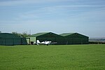
Coal Aston Airfield (ICAO: EGCA), also known as Apperknowle Airstrip, is a general aviation airfield located in the village Apperknowle, Derbyshire, 5.8 mi (9.3 km; 5.0 nmi) south of Sheffield. The unlicensed airfield is just south of a ridge of high ground to the north-east of Dronfield, close to the villages of Summerley, Apperknowle and Coal Aston. There has been a Coal Aston airfield since the World War I, though not here; RAF Coal Aston was on what is now the Jordanthorpe estate in south-east Sheffield, 1.7 miles (2.7 km; 1.5 NM) to the north-west. By the late 1920s this had become a civil field which promised, until World War II, to become Sheffield's airport. The airfield is operated from an on-site farmhouse and prior permission is required for landing. Its single strip grass runway is 660 m long and not entirely flat, with a dip in the middle and a hump at the eastern end. The older hangar at Coal Aston is a Blister-type hangar, a type made familiar during the interwar years. It was erected by United Steel Companies Limited (later British Steel) in 1961. The runway was then at its maximum length of around 800 m; it was reduced to 660 m in 2015. A second hangar was erected in the 1980s next to the blister. In 1995, the airstrip achieved permanent permission for use as an airfield; it is now one of the last remaining traditional grass airfields in Derbyshire. A public footpath follows the northern and western perimeter of the airfield. There is no public right of way across the site. Overnight parking of aircraft is possible and hangarage is available in one of the two hangars on site. A range of aircraft types may be accepted to the airfield at the owners' discretion. On 28 May 2017, Europa G-NDOL crashed on Summerley Road, several hundred meters short of the runway in the nearby village of Summerley, while on final approach to Coal Aston Airfield. The pilot, its owner and sole occupant, was killed in the accident.