River Bradford
Derbyshire geography stubsDerwent (Derbyshire) catchmentEngland river stubsRivers and valleys of the Peak DistrictRivers of Derbyshire ... and 1 more
Use British English from January 2018

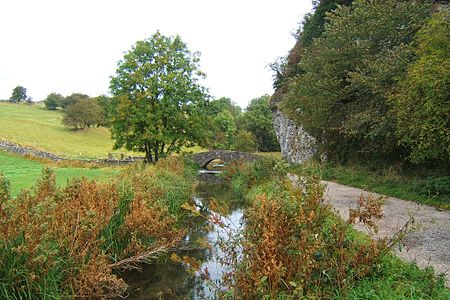
The River Bradford is a river in the Peak District National Park in Derbyshire. Its source is on Gratton Moor and after passing below Youlgreave it joins the River Lathkill at Alport. Less than 4 miles (7 km) in length, its waters are very clear due to the limestone rock over which it flows, and its width has been enhanced by a number of weirs which also encourage white-throated dippers to breed in the ponds created. The river is owned and managed by the Haddon Estate and is home to brown trout and white-clawed crayfish. The valley is known as Bradford Dale, and the Limestone Way passes through it.
Excerpt from the Wikipedia article River Bradford (License: CC BY-SA 3.0, Authors, Images).River Bradford
Alport Lane, Derbyshire Dales
Geographical coordinates (GPS) Address Nearby Places Show on map
Geographical coordinates (GPS)
| Latitude | Longitude |
|---|---|
| N 53.1767 ° | E -1.6722 ° |
Address
Alport Lane
DE45 1LG Derbyshire Dales
England, United Kingdom
Open on Google Maps


