Tabua, Madeira
Autonomous Region of Madeira stubsFreguesias of Ribeira Brava, MadeiraPortugal geography stubs

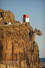
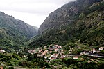
Tabua is a parish in the municipality of Ribeira Brava in the island of Madeira. It is located on the south coast, west of Funchal. The population in 2011 was 1,156, in an area of 11.03 km2. The municipality has a road which connects Calheta with Funchal, the capital, by road. The municipality of Ponta do Sol is to the west, and the municipality of São Vicente is to the north. On its southern border, the municipality borders the Atlantic.
Excerpt from the Wikipedia article Tabua, Madeira (License: CC BY-SA 3.0, Authors, Images).Tabua, Madeira
Estrada Banda D'Além,
Geographical coordinates (GPS) Address Nearby Places Show on map
 Continue reading on Wikipedia
 Geographical coordinates (GPS)
| Latitude | Longitude |
|---|---|
| N 32.683 ° | E -17.067 ° |
Address
Estrada Banda D'Além
Estrada Banda D'Além
9350-253 (Ribeira Brava)
Portugal
Open on Google Maps