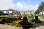
Castle of Braga (Portuguese: Castelo de Braga) is a historical fortification and defensive line encircling the city of Braga. While, in fact, the only remains of this structure are the various gates and towers along its perimeter, the main keep tower, located in the civil parish of São João do Souto, is the only true remnant of the medieval castle.
The old castle, today demolished, had an approximate rectangular plan, with towers on each vertex. Of the walls of the city, only the gate, tower of Santiago, tower of São Sebastião and Porta Nova remain (the latter being completely remodeled in a Rococo style and completely different stylistically).Its perimeter barely exceeded 2,000 metres (6,600 ft), and was delimited (today) in the east by the Praça da República, west by the Rua do Castelo (keep and castle), Rua de São Marcos, Rua do Anjo, Largo de Santiago, Rua do Alcaide, Largo de Paulo Orósio, Rua de Jerónimo Pimentel, Campo das Carvalheiras, Avenida de São Miguel o Anjo, Largo da Porta Nova, Rua dos Biscainhos, Praça do Conselheiro Torres e Almeida and Rua dos Capelistas (walls).The demolition of the grounds began in 1858 in the Largo do Barão de S. Martinho, with the destruction of the Souto Gate, followed by the Eastern and São Bento Gates, still in the 19th century. After the beginning of the 20th century, many other lines of the castle were destroyed between the Arco da Porta Nova and Rua dos Biscainhos, and from Rua dos Biscainhos and Rua do Alcaide (whose houses abutted the wall, between Campo da Vinha and Praça do Município and Rua de São Marcos). Few remnants of the medieval lines remain today. The ancient wall can be seen in some of the backyards of homes along the Rua do Anjo and Rua de São Marcos. Still, further, there still exists the Gate of São Tiago, even if partially altered due to the construction in the second half of the 18th century, through the addition of the Capela da Senhora da Torre. Along Rua de São Marcos, in 1985, one property owner constructed over the foundations of one part of the wall, while in March 1990, there was a collapse of one part of the ancient wall, during the demolition of the old Facho garment factory.


