place

Dudbridge railway station
Disused railway stations in GloucestershireFormer Midland Railway stationsGloucestershire building and structure stubsPages with no open date in Infobox stationRailway stations in Great Britain closed in 1947
Railway stations in Great Britain opened in 1867South West England railway station stubsStroud DistrictUse British English from March 2015
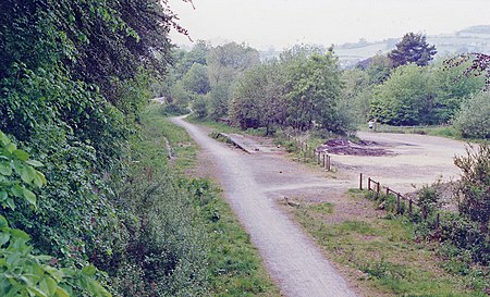
Dudbridge station site geograph 3421764 by Ben Brooksbank

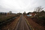
Dudbridge railway station served the Stroud suburb of Dudbridge and the village of Selsley, little more than 1 mile (1.6 km) from Stroud, in Gloucestershire, England. The station was on the 5+3⁄4 miles (9.3 km) long Stonehouse and Nailsworth Railway, later part of the Midland Railway. The station opened as "Dudbridge for Stroud" with the railway in 1867. The buildings included a two-storey station-master's house and though there was originally only a single platform, the station was a passing place on the single-track branch line. In 1885, the Midland Railway built a very short branch line from Dudbridge to Stroud. The new line opened for goods traffic in 1885 and for passengers the following year, at which point Dudbridge became a junction station, and a second platform was built. The Stonehouse and Nailsworth Railway, along with the rest of the Midland Railway, became part of the London Midland and Scottish Railway at the 1923 Grouping. Passenger services were suspended on the line as an economy measure to save fuel in June 1947, and were officially withdrawn from 8 June 1949. Dudbridge remained open for goods traffic until 1966. The station buildings survived and were occupied until the early 1990s, when they were demolished. Most of the former station site has now been consumed by the redevelopment of the A419 road for the Ebley bypass, with the Dudbridge to Ryeford section used as route for the roadway.

Excerpt from the Wikipedia article Dudbridge railway station (License: CC BY-SA 3.0, Authors, Images).

Dudbridge railway station
A419,

Geographical coordinates (GPS) Address Nearby Places
placeShow on map

Wikipedia: Dudbridge railway stationContinue reading on Wikipedia

Geographical coordinates (GPS)

Latitude Longitude
N 51.7379 ° E -2.2427 °
placeShow on map

Address

A419
GL5 5JP , Dudbridge
England, United Kingdom
mapOpen on Google Maps

Dudbridge station site geograph 3421764 by Ben Brooksbank
Share experience

Nearby Places

Cainscross
Cainscross

Cainscross is a suburban town and civil parish in Gloucestershire, England, bordering the town of Stroud and forming part of the Stroud urban area. The parish includes the communities of Ebley, Cashes Green and Cainscross, and part of Dudbridge. The population of the civil parish was 6,680 (in 2001) of which 14.6% are in the 5–14 age group. The area is predominantly white (98.4%) with a high proportion of lone parent households with dependent children in comparison to the Stroud and county averages. 18.8% of the household rent from a social landlord, 6.2% of household are claiming housing benefit, and 22.4% of households have no car – again all much higher than the county or Stroud profiles. Lone pensioner households are also high, at 18.2%, with smaller proportions of people providing unpaid care, and higher social service referrals for the over-75s than elsewhere. As a relatively prosperous parish within Gloucestershire, there are low levels of burglary, theft of motor vehicles; the numbers of serious and fatal road traffic accidents compared to the county average. The percentage of young offenders resident in the area and of children with low scores at key stages 1–3, are also below the Stroud and county averages. The Town Council is hoping to improve provision of community and youth facilities; these, along with levels of open space, were identified in the 2006 Parish Plan as key issues along with library, post office and evening bus services. The Town Council is looking to improve their play areas and make them inclusive and at present are raising funds to re-vamp Victory Park Play area. Cainscross is well served with local amenities, including a post office and a medium-sized co-operative supermarket. It is well connected to Stroud (only a 25-minute walk away) with frequent bus services to Stonehouse, Gloucester and Cheltenham. The Stroudwater Canal is easily accessible to the south, as is Selsley Common. Stroud town centre lies 1.6 miles (2.5 km) to the east.

Cashes Green Halt railway station

Cashes Green Halt was opened on 22 January 1930 on what is now the Golden Valley Line between Stroud and Stonehouse. This line was opened in 1845 as the Cheltenham and Great Western Union Railway from Swindon to Gloucester and this was one of many small stations and halts built on this line for the local passenger service. This particular halt was built later than the rest and was built to serve the then new Cashes Green housing development west of Stroud in response to a public request. The halt was just west of the Cashes Green Road overbridge and consisted of a pair of timber platforms, along with corrugated iron shelters, using materials recovered from the Chalvey Halt on the Windsor line. Access to the up platform was via steps from the overbridge. These were later replaced with a Tarmac slope. (C1957) The down platform was accessed from a similar slope into the 'birdcage' (still extant - 2010) which runs parallel to the railway and then proceeds at right angles south down to Upper Church Road, Cainscross. Originally the 'birdcage' (so-called because it consists of metal railings on either side giving the pedestrian the impression that they are actually in a 'birdcage') ended in a foot crossing over the railway approximately 100 yards west of the halt. It was diverted and the crossing closed at about the time the halt was built. Closure of the halt came in November 1964 following the withdrawal of local stopping passenger services on the line. No trace of the halt remains today.