place

Wain Wood

Forests and woodlands of HertfordshireNorth Hertfordshire DistrictSites of Special Scientific Interest in HertfordshireSites of Special Scientific Interest notified in 1986
Wain Wood
Wain Wood

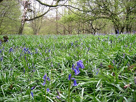
Wain Wood is an ancient woodland extending to 19.2 hectares (47 acres) near Preston in North Hertfordshire. The site is a Site of Special Scientific Interest which was notified in 1986 under the Wildlife and Countryside Act 1981. The local planning authority is North Hertfordshire District Council. It is a relic of a large forest which extended from Hitchin to Hatfield.

Excerpt from the Wikipedia article Wain Wood (License: CC BY-SA 3.0, Authors, Images).

Wain Wood
Preston Road, North Hertfordshire

Geographical coordinates (GPS) Address Nearby Places
placeShow on map

Wikipedia: Wain WoodContinue reading on Wikipedia

Geographical coordinates (GPS)

Latitude Longitude
N 51.91554 ° E -0.28577 °
placeShow on map

Address

Preston Road

Preston Road
SG4 7TZ North Hertfordshire
England, United Kingdom
mapOpen on Google Maps

Wain Wood
Wain Wood
Share experience

Nearby Places

Preston, Hertfordshire

Preston is a village and civil parish about 3 miles (4.8 km) south of Hitchin in Hertfordshire, England. At the 2011 Census the population was 420.The village grew up around the Templar holdings at Temple Dinsley. The first church was mentioned in 1252, when six acres (24,000 m2) of land was given to nuns from Elstow, Bedfordshire. Temple Dinsley passed on to the Knights Hospitaller after the dissolution of the Templars. When the Hospitallers were in turn dissolved in 1542, the manor went to Sir Ralph Sadleir. The current house at Temple Dinsley dates from 1714, and became Princess Helena College in 1935. The college closed in 2021.In the 17th century the village became linked with John Bunyan, who used to hold services in a natural amphitheatre now called Bunyan's Dell. Prior to 1894, Preston and neighbouring Langley were part of the parish of Hitchin, together forming a long salient to the south of the town itself. Preston and Langley became separate civil parishes as a result of the Local Government Act 1894, with effect from the first parish meeting on 4 December 1894. Preston civil parish was then included in the Hitchin Rural District between 1894 and 1974, when it became part of North Hertfordshire. The parish of Preston was enlarged in 1955 with the addition of territory from the neighbouring parishes of St Ippolyts and King's Walden.St Martin's, the local Anglican church, opened in 1900. The ruined Minsden Chapel, reputed to be haunted, is located near the village, though is actually in Langley civil parish.

Charlton, Hertfordshire

Charlton is a hamlet in the county of Hertfordshire, in the East of England. It is a component hamlet of the market town of Hitchin, forming a part of the Hitchin Priory ward. Its rural character is protected as a Conservation Area. Situated east of the Chilterns AONB, it lies 30 miles north of London. The manor of Charlton is mentioned in the Domesday Book as belonging to Ilbert of Hitchin. It later came into the possession of the Knights Templar, and then by the Knights Hospitaller with the manor of Temple Dinsley until the suppression of the latter order. The manor subsequently came to Edward Pulter, who sold it in 1582 to Ralph Radcliffe from which time it was part of the property of Hitchin Priory.Charlton House is a Grade II listed building and the birthplace of inventor Henry Bessemer in 1813. At the time his father, Anthony Bessemer, operated a type foundry in the village. The mill-wheel was adapted by his grandfather to power a small foundry. The water-mill was therefore converted to a foundry during the occupancy of the Bessemer family and back to a mill again afterwards. There are remains of a windmill less than half a mile from the Windmill pub from which it may have taken its name. There was, until the 1970s, also a water-wheel in the mill-race in the yard of Wellhead Farm. According to an article by Peter Harkness in Vol 1, No 1 of "Old Hitchin Life" the Harkness family's now world-famous rose-nursery was, in the late 19th century, based in Charlton as well as Bedale, in Yorkshire, with Robert Harkness moving into Charlton House (Bessemer's birthplace) in 1895.

Hill End Pit
Hill End Pit

Hill End Pit (also called Hill End Farm Pit or Hitch Wood Pit) is a 0.7-hectare (1.7-acre) nature reserve on the site of a former chalk pit, in St Paul's Walden in North Hertfordshire. It was formerly managed by the Herts and Middlesex Wildlife Trust (HMWT). In February 2016 HMWT announced that three sites, Barkway Chalk Pit, Hill End Pit and Pryor's Wood, which HMWT managed on behalf of their owner, North Hertfordshire District Council, were to return to Council management as the Trust was no longer able to meet the cost. It has the largest colony of Azeca goodalli snails in Hertfordshire. Plants include viper's bugloss, cowslip and marjoram, there are butterflies such as common blue and gatekeeper, and many birds including woodpeckers.The site is a Regionally important geological site (RIGS), dating to the Turonian age of the late Cretaceous around 90 million years ago, and was formerly a Site of Special Scientific Interest. According to A Geological Conservation Strategy for Hertfordshire, published by the Hertfordshire RIGS Group: This pit is of national stratigraphic and international palaeontological importance, but has lost its original SSSI status and is now very degraded. It is the type locality of the Hitch Wood Hardground at the top of the Chalk Rock. This hardground is exceptionally fossiliferous here, and has probably yielded more fossils of all groups (notably ammonites) than any other Chalk Rock locality apart from the Kensworth Chalk Pit GCR site, Bedfordshire.The site gives its name to the siliceous sponge genus Hillendia, and is the type locality of the genus, and two fossil ammonite species, Subprionocyclus hitchinensis and Subprionocyclus branneri have been described from this site after being discovered there.It is shown on the Natural England Magic map as one of the "Geological places to visit".The site is located off a track leading from Hitchwood Lane to Hill End Farm Lane. It is difficult to find, but the site noticeboard is visible through a gap in the hedge on the left hand side of the track.