place

Columbia Point, Boston

Boston Harbor peninsulas and former islandsColumbia Point, BostonNeighborhoods in Boston
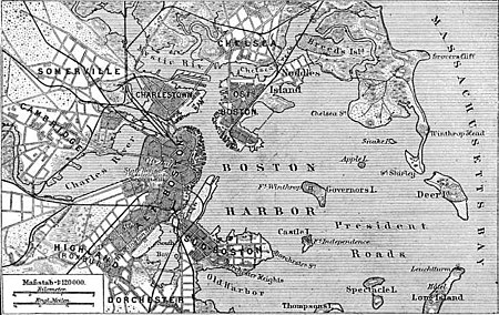
Situationsplan von Boston (Massachusetts)

Columbia Point, in the Dorchester neighborhood of Boston, Massachusetts sits on a peninsula jutting out from the mainland of eastern Dorchester into the bay. Old Harbor Park is on the north side, adjacent to Old Harbor, part of Dorchester Bay. The peninsula is primarily occupied by Harbor Point, the University of Massachusetts Boston, the John F. Kennedy Presidential Library and Museum, the Edward M. Kennedy Institute for the United States Senate, and a complex at the former Bayside Expo Center, Boston College High School, and the Massachusetts Archives. The Boston Harborwalk follows the entire coastline.

Excerpt from the Wikipedia article Columbia Point, Boston (License: CC BY-SA 3.0, Authors, Images).

Columbia Point, Boston
Mount Vernon Street, Boston Dorchester

Geographical coordinates (GPS) Address Nearby Places
placeShow on map

Wikipedia: Columbia Point, BostonContinue reading on Wikipedia

Geographical coordinates (GPS)

Latitude Longitude
N 42.313719444444 ° E -71.033436111111 °
placeShow on map

Address

University of Massachusetts Boston

Mount Vernon Street 150
02125 Boston, Dorchester
Massachusetts, United States
mapOpen on Google Maps

Situationsplan von Boston (Massachusetts)
Share experience

Nearby Places

Calf Pasture Pumping Station Complex

The Calf Pasture Pumping Station Complex is a historic sewage treatment facility at 435 Mount Vernon Street on Columbia Point in the Dorchester section of Boston, Massachusetts which was built in the 1880s. The surrounding community was, in the 17th and 18th centuries, and through to the mid-19th century, a calf pasture: a place where nearby Dorchester residents took their calves for grazing. It was largely an uninhabited marshland on the Dorchester peninsula. Its size was originally 14 acres (5.7 ha). Many landfills, subsequent to that time, have enlarged the land size to 350 acres (140 ha) in the 20th century. In the 1880s, the calf pasture was used as a Boston sewer line and pumping station, known as the Calf Pasture Pumping Station Complex. This large granite structure, the first sewage treatment station built in the city, was built in 1883. It still stands and in its time was a model for treating sewage and helping to promote cleaner and healthier urban living conditions. It pumped waste to a remote treatment facility on Moon Island in Boston Harbor, and served as a model for other systems worldwide. This system remained in active use and was the Boston Sewer system's headworks, handling all of the city's sewage, until 1968 when a new treatment facility was built on Deer Island. The pumping station is also architecturally significant as a Richardsonian Romanesque designed by the then Boston city architect, George Clough. It is also the only remaining 19th century building on Columbia Point.The facility was listed on the National Register of Historic Places in 1990. This building is currently under study as a Boston Landmark by the Boston Landmarks Commission. In January 2020, the University of Massachusetts Building Authority issued a request for information from developers to restore the facility and to construct a mixed-use facility on an adjacent 10-acre site, receiving eight proposals in response by the following September. In July 2021, UMass officials issued a request for proposal for the facility and the adjacent site.

South Boston CSO Storage Tunnel

The South Boston CSO Storage Tunnel, also known as the North Dorchester Bay CSO Storage Tunnel, is a large underground facility designed to reduce untreated sewage discharges into Boston Harbor from the Massachusetts Water Resources Authority combined sewer and stormwater system. It was opened on July 23, 2011, and is part of the federally mandated Boston Harbor Cleanup project. CSO stands for Combined Sewer Overflow. The main part of the facility is a tunnel 17 feet (5.2 m) in diameter, running 2.5 miles (4.0 km) along the harbor front. The tunnel starts at an Odor Control Building (42.3225°N 71.0490°W / 42.3225; -71.0490 (Odor Control Building)), continues along the harbor front, with a midpoint near 42.3294°N 71.0373°W / 42.3294; -71.0373, and ends with a pump station at 42.3385°N 71.0216°W / 42.3385; -71.0216 (Pumping station).Combined sewers are problematic because during heavy storms, they are forced by a high volume of rainwater from storm drains to carry untreated sanitary sewer output into Boston harbor, including dangerous amounts of human waste. In addition to the tunnel project, the MWRA is undertaking costly sewer separation in parts of South Boston near the Reserved Channel, and reconfiguring various drains and outflows. The tunnel provides a buffer to allow some combined sewers to remain in service. It has sufficient buffer capacity to hold combined sewage and rain water during most storms, helping to eliminate the Combined Sewer Outflow events that polluted nearby beaches on average 20 times per year. After the storm is over, the tunnel is "dewatered" back into the network at a rate the Deer Island Waste Water Treatment Plant can handle.