place

Kesgrave High School

Academies in SuffolkSecondary schools in SuffolkUse British English from February 2023

Kesgrave High School is a secondary school in Kesgrave in the English county of Suffolk. The school has over 1800 pupils aged 11 to 18. The school has been awarded Eco-school status and has 20 solar panels on top of the technology block. It has been awarded the Green Flag Award, becoming the first school in the region to have achieved such a feat. A study for Sustrans noted that 61% of the pupils cycled to the school. This is largely due to the installation of a large cycle lane through the housing estate and along the main road. The school actively encourages walking or cycling and provides bicycle storage facilities.The school has undergone extension in recent years, including the construction of a new Creative Media Department, a Communications block, a PE block and a sixth form block. The school underwent further extension in the Summer of 2013 with the demolishing of the History block, one of the oldest blocks in the school, and the building of the new humanities block which was completed in April 2014. Ofsted rated it as good following the most recent inspection. Prior to this, the school had been rated as outstanding. Kesgrave High School was the first school in Britain to ban skirts for girls.On 24 June 2015, the school's Space Club achieved the world record for the highest altitude paper plane launch, reaching an altitude of 35,043 meters.

Excerpt from the Wikipedia article Kesgrave High School (License: CC BY-SA 3.0, Authors).

Geographical coordinates (GPS)

Latitude Longitude
N 52.06683 ° E 1.24412 °
placeShow on map

Address

Kesgrave High School

Main Road
IP5 2PB , Grange Farm
England, United Kingdom
mapOpen on Google Maps

Phone number

call+441473624855

Website
kesgrave.suffolk.sch.uk

linkVisit website

linkWikiData (Q6394932)
linkOpenStreetMap (25697218)

Share experience

Nearby Places

Bealings railway station

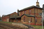
Bealings railway station was a station in Little Bealings, Suffolk, on the line between Ipswich and Lowestoft. It was 7 miles 20 chains (11.7 km) down the line from Ipswich. While the station closed on 17 September 1956, the line remains open and both the station building and platforms survive. It was opened by the Eastern Union Railway (EUR) on 1 June 1859 when the full East Suffolk Line opened between Great Yarmouth in Norfolk and Ipswich in Suffolk. The station buildings were designed by Frederick Barnes (architect), who also designed Woodbridge station. By the 1860s the railways in East Anglia were in financial trouble, and most (including the EUR) were leased to the Eastern Counties Railway; they wished to amalgamate formally, but could not obtain government agreement for this until 1862, when the Great Eastern Railway was formed by amalgamation. Thus in 1862 the operation of Bealings Station was taken over by the Great Eastern Railway who operated the station until 1923 when grouping saw the Great Eastern Railway taken over by the London and North Eastern Railway. The July 1922 Bradshaw's Guide showed seven up services (towards Ipswich) and seven down services calling at the station, with two services each way on Sundays. Most services were local trains which would originate or terminate at Ipswich and call at most stations on the East Suffolk Line. However, the station did enjoy a main line service direct to Liverpool Street. Bradshaw's stated that the 08:17 departure conveyed first and third class Pullman carriages (there was no second class at this time), arriving in Liverpool Street at 10:30. The return working was at 15:18, arriving back in Bealings at 17:22. From 1916 the station was the railhead for Martlesham Heath Airfield. In 1919 the goods yard was recorded as having three roads one of which served a small goods shed (the building on the left-hand side of the picture).After World War II the railways were nationalised and Bealings station became part of British Railways' Eastern Region. Lack of patronage saw the station close in September 1956 and the goods yard followed in April 1965. The signal box (opened in 1884 with 18 levers for signals and points) remained in use, however, as a block post to divide up the Westerfield-Woodbridge section and to operate the level crossing gates. The box lasted until 1984, when it was closed as a result of the introduction of RETB (Radio Electronic Token Block) signalling on the East Suffolk line; at the same time, the manual level crossing gates were replaced by the current automatic half-barriers. The station building is still extant today and is occupied by the Mallard Business Centre.