place

Croydon Minster

19th-century Church of England church buildingsAnglican Diocese of SouthwarkAnglo-Catholic church buildings in the London Borough of CroydonBurned buildings and structures in the United KingdomChurch of England church buildings in the London Borough of Croydon
Churches completed in 1870Grade I listed buildings in the London Borough of CroydonHistory of the London Borough of CroydonRebuilt churches in the United Kingdom
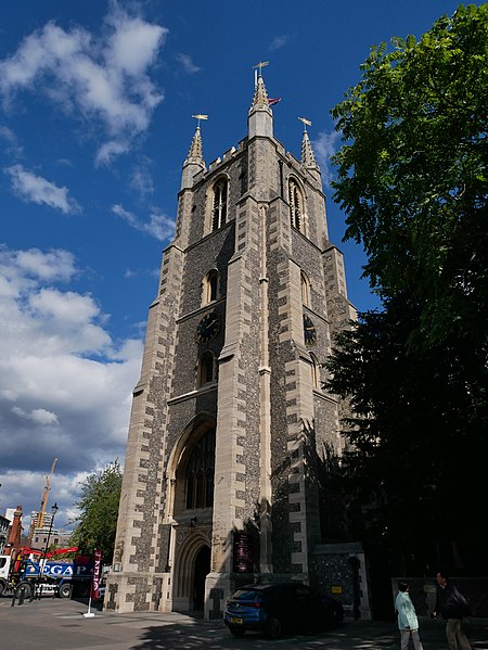
Tower of Croydon Minster (Southwest View 01)

Croydon Minster is the parish and civic church of the London Borough of Croydon. There are currently more than 35 churches in the borough, with Croydon Minster being the most prominent. It is Grade I listed.Six Archbishops of Canterbury are buried in the church: Edmund Grindal (d.1583), John Whitgift (d.1604), Gilbert Sheldon (d.1677), William Wake (d.1737), John Potter (d.1747), and Thomas Herring (d.1757).

Excerpt from the Wikipedia article Croydon Minster (License: CC BY-SA 3.0, Authors, Images).

Croydon Minster
Church Street, London Broad Green (London Borough of Croydon)

Geographical coordinates (GPS) Address Website External links Nearby Places
placeShow on map

Wikipedia: Croydon MinsterContinue reading on Wikipedia

Geographical coordinates (GPS)

Latitude Longitude
N 51.3727 ° E -0.1061 °
placeShow on map

Address

Croydon Minster (St John The Baptist)

Church Street
CR0 1RF London, Broad Green (London Borough of Croydon)
England, United Kingdom
mapOpen on Google Maps

Website
southwark.anglican.org

linkVisit website

linkWikiData (Q5189677)
linkOpenStreetMap (140546672)

Tower of Croydon Minster (Southwest View 01)
Share experience

Nearby Places

Croydon
Croydon

Croydon is a large town in South London, England, 9.4 miles (15.1 km) south of Charing Cross. Part of the London Borough of Croydon, a local government district of Greater London, it is one of the largest commercial districts in Greater London, with an extensive shopping district and night-time economy. The entire town had a population of 192,064 as of 2011, whilst the wider borough had a population of 384,837. Historically an ancient parish in the Wallington hundred of Surrey, at the time of the Norman conquest of England Croydon had a church, a mill, and around 365 inhabitants, as recorded in the Domesday Book of 1086. Croydon expanded in the Middle Ages as a market town and a centre for charcoal production, leather tanning and brewing. The Surrey Iron Railway from Croydon to Wandsworth opened in 1803 and was an early public railway. Later 19th century railway building facilitated Croydon's growth as a commuter town for London. By the early 20th century, Croydon was an important industrial area, known for car manufacture, metal working and Croydon Airport. In the mid 20th century these sectors were replaced by retailing and the service economy, brought about by massive redevelopment which saw the rise of office blocks and the Whitgift Centre, the largest shopping centre in Greater London until 2008. Historically, the town formed part of the County of Surrey, and between 1889 and 1965 a county borough, but was amalgamated into Greater London in 1965. Croydon lies on a transport corridor between central London and the south coast of England, to the north of two high gaps in the North Downs, one taken by the A23 Brighton Road and the main railway line through Purley and Merstham and the other by the A22 from Purley to the M25 Godstone interchange. Road traffic is diverted away from a largely pedestrianised town centre, mostly consisting of North End. East Croydon is a major hub of the national railway transport system, with frequent fast services to central London, Brighton and the south coast. The town is also at the centre of the only tramway system in southern England.

Surrey Street Pumping Station, Croydon

Surrey Street Pumping Station is a Grade II listed pumphouse in Croydon, South London, England, that was built in four phases. It is the site of a well that "had been more or less public ever since the town existed". It was opened by the Archbishop of Canterbury on 11 December 1851, making Croydon one of the first towns to have a combined water and sewage system under the 1848 Public Health Act, and to Chadwick’s arterial-venous design. The water was pumped from the wells, up Park Hill to a cylindrical brick reservoir with a domed roof to provide a constant supply of fresh piped water. Prior to its opening, the inhabitants of Croydon used the river Wandle, streams and shallow wells, which were often contaminated by seepage from privies and cesspools. Parts of Norwood were served with water from the Lambeth Water Company, a private company established by an act of parliament in 1785 (25 Geo III cap LXXXIX).Soon after it opened, the pumping station was involved in a landmark legal case about the abstraction of water from wells. The opening coincided with a reduction of water in the river Wandle that had been predicted by the river's millers. They believed they had a strong case under riparian law that they should not be harmed by the abstraction. The Lords disagreed and determined on the 27th of July 1859 that "the course and direction of underground waters were considered too uncertain and too little known, to be the foundation of any (riparian) rights in them". Water levels in the river subsequently increased, suggesting the reason for the low levels in the river was a lack of rainfall. It is somewhat ironic that in 1912 Croydon objected to the abstraction of water at Purley by the East Surrey Water company for fear it would damage their supply.