place

Piscop

Communes of Val-d'OiseVal-d'Oise geography stubs
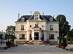
Piscop Mairie 9
Piscop Mairie 9

Piscop (French pronunciation: [pisko] (listen)) is a commune in the Val-d'Oise department in Île-de-France in northern France.

Excerpt from the Wikipedia article Piscop (License: CC BY-SA 3.0, Authors, Images).

Piscop
Rue de la Libération, Sarcelles

Geographical coordinates (GPS) Address Nearby Places
placeShow on map

Wikipedia: PiscopContinue reading on Wikipedia

Geographical coordinates (GPS)

Latitude Longitude
N 49.0131 ° E 2.3447 °
placeShow on map

Address

Rue de la Libération

Rue de la Libération
95350 Sarcelles
Ile-de-France, France
mapOpen on Google Maps

Piscop Mairie 9
Piscop Mairie 9
Share experience

Nearby Places

Fort de Domont
Fort de Domont

The Fort de Domont was built following the Franco-Prussian War to defend Paris. Located to the north of Paris in Domont, the fort was part of an outer ring of fortifications built in response to improvements in the range and effectiveness of artillery since the construction of the Thiers fortifications of the 1840s. It was built between 1875 and 1879 in accordance with improved principles of fortification developed for the Séré de Rivières system. Work on the fort began in 1874 and were completed in 1878. The fort covered an area of 12 hectares (30 acres) and its garrison comprised 1175 men and officers.The fort's artillery fire supported its neighbors, the Fort de Montmorency and the Fort de Montlignon. The pentagonal fort was entered through the south side, facing Paris. It featured a double caponier on the point facing outward, and two flanking caponiers on the east and west sides. The fort's main armament was a 155mm Mougin turret, added in 1884. Other artillery on the firing terrace, or cavalier, was of 120mm and 95mm caliber. The fort's artillery dominated the plains to the north, as well as the railway line to Pontoise.On 3 and 4 September 1914, the fort fired on German scout parties in the vicinity of Luzarches, the only Parisian fortification to fire on Germans during World War I. The fort was occupied by German forces during World War II, who blew up the fort's ammunition stockpile before evacuating on 26 August 1944.The fort was used by the French Post (PTT) as an ionospheric research station during the 1950s, followed by the Ministry of Agriculture. The fort was briefly used by a private company for radiography work in the 1990s before it became a training center for the fire services in 1993. It is now known as the Fort Domont Training Center ("Centre de Formation et d'entrainement, Fort de Domont"). The center provides comprehensive training, including live fire exercises

Fort de Montmorency
Fort de Montmorency

The Fort de Montmorency was built following the Franco-Prussian War to defend Paris. Located to the north of Paris in Montmorency, the fort was part of an outer ring of fortifications built in response to improvements in the range and effectiveness of artillery since the construction of the Thiers fortifications of the 1840s. It was built between 1875 and 1879 in accordance with improved principles of fortification developed for the Séré de Rivières system. The fort defended its neighbors, the Fort de Domont and the Fort de Montlignon, as well as the town of Saint-Denis. The fort saw no action in the first or second world wars, but its prominent height made it ideal for use as a telecommunications relay station. In 1947 the French Air Force occupied the site, and by 1952 communication cables were installed to link the fort to the national air defense communications system. In 1956 the Fort de Montmorency became the national headquarters for Air Force communications. The fort was designated Base aerienne 285.Base aerienne 285 was disbanded in 1968 and the fort was first placed under the jurisdiction of ''Base aerienne 104 at Le Bourget, and later under the control of the French Air Force hardened command center at Base aerienne 921 at Taverny, at the west end of the Montmorency forest. From 1992 the fort has served as a training center for security forces associated with the Taverny center, the Centre d'Initiation aux Techniques Commandos.The fort remains occupied by the military and is not open to the public.

Cimetière des Champeaux de Montmorency

The Cimetière des Champeaux de Montmorency, at Montmorency, Val-d'Oise in Île-de-France, is a cemetery first established in the 17th-century. It has the particularity of being the largest Polish burial place in France, hence its appellation as the "Pantheon of the Polish Emigration". It is located 15 km north of Paris and adjacent to the spa resort of Enghien-les-Bains. That it fell to Montmorency to become the main necropolis of the Polish diaspora in the country is due to two Polish political exiles, who happened to be staying at the nearby spa at the time of their death and were buried in the local cemetery. They were the statesman and poet, Julian Ursyn Niemcewicz, one time Polish envoy to the United Kingdom and Karol Kniaziewicz, politician and brigadier general in Napoleon's Grande Armée. Since their interments in the early part of the 19th-century, a succession of noted exiled Poles found their final resting place in the cemetery. There are over 276 Polish burials, among them the poets Adam Mickiewicz, the national bard, and Cyprian Kamil Norwid, statesman Adam Jerzy Czartoryski, and the diplomat and head of the Polish resistance in France during WWII, Aleksander Kawalkowski. The cemetery has become one of the national symbols of Polish resistance to all forms of oppression, and each Spring, it is the rallying place for Poles living in the Paris area, who go there to commemorate their historical leaders and artists.