place

Swinstead

Civil parishes in LincolnshireSouth Kesteven DistrictUse British English from December 2013Villages in Lincolnshire
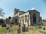
Swinstead geograph.org.uk 106113

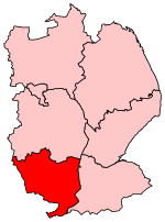
Swinstead is a village and civil parish in the South Kesteven district of Lincolnshire, England. It is situated 5 miles (8.0 km) west from Bourne, 9 miles (14.5 km) north from Stamford and 11 miles (17.7 km) south-east from Grantham. It is a village of just over 100 households, the population of the civil parish being measured at 234 in the 2011 census. Swinstead parish church is dedicated to St Mary. The village's last public house closed in 2008, and the nearest amenities are 2 miles (3.2 km) away at Corby Glen. Adjacent villages include Creeton, Swayfield and Grimsthorpe. England international footballer Beaumont Jarrett was vicar of Swinstead from 1883 to 1895.In William Shakespeare's King John, King John stayed in "Swinsted Abbey", but it is Swineshead Abbey that he stayed: this confusion was common in late-sixteenth century texts, for Swinstead is about 25 miles from Swineshead.

Excerpt from the Wikipedia article Swinstead (License: CC BY-SA 3.0, Authors, Images).

Swinstead
High Street, South Kesteven Swinstead

Geographical coordinates (GPS) Address Nearby Places
placeShow on map

Wikipedia: SwinsteadContinue reading on Wikipedia

Geographical coordinates (GPS)

Latitude Longitude
N 52.79047 ° E -0.492239 °
placeShow on map

Address

High Street

High Street
NG33 4PN South Kesteven, Swinstead
England, United Kingdom
mapOpen on Google Maps

Swinstead geograph.org.uk 106113
Share experience

Nearby Places

Counthorpe
Counthorpe

Counthorpe is a hamlet in the civil parish of Counthorpe and Creeton in the South Kesteven district of Lincolnshire, England. It adjoins the hamlet of Creeton and lies 5 miles (8 km) south-west from Bourne and 3 miles (5 km) south from Corby Glen, and on the River Glen. In the Domesday account Counthorpe is written as "Cudetorp". Before the Conquest lordship was held by Earl Morcar; after, Drogo de la Beuvrière became Tenant-in-chief.Counthorpe shares the Grade I listed Anglican parish church at Creeton, dedicated to St Peter. The church is of late Decorated style. A restoration of 1851 discovered the arches and piers of a former Norman aisle. The church holds a chained bible from 1611. Two examples of Saxon crosses stand in the churchyard, with 20 stone coffins considered to mark the interment of Cistercian monks of Vallis Dei abbey in the neighbouring parish of Edenham.Counthorpe was formerly a hamlet of Castle Bytham and had, up to the 16th century, its own parochial chapel, but was annexed to Creeton in 1860.Counthorpe is recorded in the 1872 White's Directory as a small village in the parish of Castle Bytham, but which, for ecclesiastical purposes, became on 30 June 1860 united with Creeton. The village was 2 miles (3 km) from Little Bytham railway station. At this time Counthope was a township of 78 people in about 130 acres (0.5 km2) of land divided between three farms; a farmer of one of these, at Counthorpe Lodge, was also a grazier.