Mount Erie (Washington)

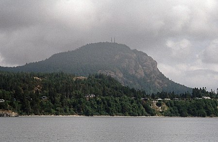
Mount Erie is a mountain on Fidalgo Island in Skagit County, Washington, United States. It is on public park land owned and managed by the city of Anacortes and is located in the south of the Anacortes Community Forest Lands. Mount Erie was named in 1841 by the Wilkes Expedition for the Battle of Lake Erie. The mountain itself was first explored in the 1960s by local climbers, including Dallas Kloke. It is known for its climbing as well as the view from the summit. The summit is accessible via a single-lane, paved road from the base. At 1,273 feet (388 m) tall, Mount Erie is the highest point on Fidalgo Island. On a clear day, Mount Baker, about 43 miles (69 km) to the northeast, and Mount Rainier, about 117 miles (188 km) to the southeast, can be seen from the summit.
Excerpt from the Wikipedia article Mount Erie (Washington) (License: CC BY-SA 3.0, Authors, Images).Mount Erie (Washington)
Erie Mountain Drive,
Geographical coordinates (GPS) Address Nearby Places Show on map
Geographical coordinates (GPS)
| Latitude | Longitude |
|---|---|
| N 48.453791292 ° | E -122.625708886 ° |
Address
Erie Mountain Drive
98221
Washington, United States
Open on Google Maps


