place

Eryrys

Pages with Welsh IPAVillages in Denbighshire
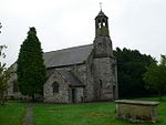
St David's, Eryrys geograph.org.uk 195555

Eryrys (Welsh pronunciation: [ɛˈrərɪs]; alternate spelling Erryrys) is a village in Denbighshire, Wales, located at approximate grid reference SJ203578, five miles south of Mold. The village is built on the limestone formation of Bryn Alyn and many limestone outcrops can be seen close by. At 355m above sea level, Eryrys is one of a number of villages with a valid claim to be the highest in Wales; others include Bwlchgwyn, Wrexham (341m, but has a still-active church, which Eryrys does not), and Garn-yr-Erw, Torfaen (390m, but has no church or pub).A number of sources suggested that the name is derived from the Welsh Erw Yrys, or the "acre (erw) of Gyrys", sometimes linked with the "Hen Gyrys o Iâl" identified as the author of early Welsh collections of proverbs. There are several limestone quarries close to the village, some now closed but others still actively serving the local cement industry. Eryrys was formerly a lead-mining community, with the remains of several mines still visible nearby, although lead-mining in the area ceased in the late 19th century. The land around Eryrys is now primarily used for sheep-grazing, with also some dairy farming. Eryrys lies on the edge of the Clwydian Range and Dee Valley Area of Outstanding Natural Beauty and many walking routes go through or around the village.

Excerpt from the Wikipedia article Eryrys (License: CC BY-SA 3.0, Authors, Images).

Geographical coordinates (GPS)

Latitude Longitude
N 53.112 ° E -3.19 °
placeShow on map

Address


CH7 4BR , Llanarmon-yn-Ial
Wales, United Kingdom
mapOpen on Google Maps

St David's, Eryrys geograph.org.uk 195555
Share experience

Nearby Places

Clwydian Range and Dee Valley

The Clwydian Range and Dee Valley (Welsh: Bryniau Clwyd a Dyffryn Dyfrdwy) is a designated Area of Outstanding Natural Beauty (AONB) located in north-east Wales, covering the Clwydian Range (Welsh: Bryniau Clwyd), and the valley of the River Dee (Welsh: Afon Dyfrdwy). Designated in 1985 as the Clwydian Range AONB, and expanded to its current form in 2011, the Area of Outstanding Natural Beauty includes: medieval field systems, open heather moorland, prehistoric hillforts, limestone crags, broad leaved woodland, wooded valleys, and farmland. The AONB falls within the jurisdiction of the local authorities of Denbighshire, Flintshire, and Wrexham County Borough, with the majority, 80% of the AONB in Denbighshire, and the remaining 20% split evenly between the other two authorities. The AONB is the largest of only five AONBs in Wales, and one of the 46 in the United Kingdom. Additionally, it is one of only 8 protected areas of Wales. Long-distance footpaths; Offa's Dyke Path, and the Clwydian Way pass through the AONB. The area of the Clwydian Range and Dee Valley AONB is 390 km2 (150 sq mi), and has been proposed by the Welsh Government to be replaced by a North East Wales National Park, which would be Wales' fourth national park. The AONB is underlain by sedimentary rocks dating from the Ordovician, Silurian, and early Carboniferous period with Triassic age rocks on lower slopes. The highest peak in the AONB is at Moel Fferna, peaking at 630 m (2,070 ft). The mainly Silurian Clwydian Range supports rounded, heather-clad hill tops which provide habitats for scarce flora and fauna and are home to Iron Age hillforts. Several areas have been designated as Sites of Special Scientific Interest and Special Areas of Conservation, with the AONB also home to multiple listed buildings, scheduled monuments, and part of the Pontcysyllte Aqueduct and Canal UNESCO World Heritage Site. In 2018, an estimated 1.1 million people visited six key sites across the AONB, generating approximately £24.1 million to the Welsh economy, according to Natural Resources Wales. The earliest evidence of human occupation in the AONB is from stone tools dated between 30 and 40,000 years ago in caves near Tremeirchion, with the oldest human-made feature in the AONB being the mound, Gop Cairn. The area is now used for a range of recreational, tourism, and agricultural purposes.