place

Beit Safafa

Arab neighborhoods in JerusalemJerusalem GovernorateNeighbourhoods of Jerusalem
BeitSafafaMay232023 04

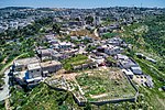
Beit Safafa (Arabic: بيت صفافا, Hebrew: בית צפפה; lit. "House of the summer-houses or narrow benches") is a Palestinian town along the Green Line, with the vast majority of its territory in East Jerusalem and some northern parts in West Jerusalem.Since the 1949 agreements, the neighborhood had been divided by the Green Line. Until 1967, the East Jerusalem part remained under Jordanian rule while the northern parts became under Israeli rule. Beit Safafa covers an area of 1,577 dunams. In 2010, Beit Safafa had a population of 5,463.

Excerpt from the Wikipedia article Beit Safafa (License: CC BY-SA 3.0, Authors, Images).

Beit Safafa
A-Nahda, Jerusalem Beit Safafa

Geographical coordinates (GPS) Address Nearby Places
placeShow on map

Wikipedia: Beit SafafaContinue reading on Wikipedia

Geographical coordinates (GPS)

Latitude Longitude
N 31.743888888889 ° E 35.205555555556 °
placeShow on map

Address

א-נהדה

A-Nahda
9328257 Jerusalem, Beit Safafa
Jerusalem District, Israel
mapOpen on Google Maps

BeitSafafaMay232023 04
Share experience

Nearby Places

Sharafat, East Jerusalem

Sharafat (Arabic: شرفات) is a Palestinian Arab neighborhood of East Jerusalem, located within approximately 5 km to the south west of the Old City of Jerusalem. It is situated close to the Palestinian town of Beit Safafa and near the Israeli settlement of Gilo in the southern portion of East Jerusalem.Sharafat is later mentioned in chronicles from the 13th and 15th centuries, Ottoman tax records from the 16th century, and the travel writings and ethnographies of European and American visitors to Palestine in the 19th and 20th centuries. During the period of Mamluk rule (c. 13th - early 16th centuries), Sharafat was home to the Badriyya a renowned family of awliya (Muslim saints) to whom the village was dedicated as a waqf (Islamic trust) by the viceroy of Damascus in the 14th century, and whose family tombs continue to be venerated to this day. After the 1948 Palestine War, Sharafat lay in the area to the east of the Green Line that was ruled by Jordan until 1967. Following the occupation West Bank, including East Jerusalem by Israel in the 1967 Six-Day War, Israel included it in its expanded Jerusalem District. In the 1970s, the Israeli government expropriated land from the village to build the settlement of Gilo, whose subsequent expansion saw the destruction of homes, vineyards and orchards in Sharafat. The Palestinian Authority (PA), established pursuant to 1993 Oslo Accords, considers Sharafat a part of its Jerusalem Governorate. In 2002, the population was made up of 978 Palestinians.