West Bradford, Lancashire
Civil parishes in LancashireForest of BowlandGeography of Ribble ValleyHistory of YorkshireUse British English from April 2015 ... and 1 more
Villages in Lancashire

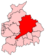
West Bradford is a village and civil parish in Lancashire, England, 2.5 miles (4 km) north of Clitheroe. The population at the 2011 census was 788. It covers some 2000 acres of the Forest of Bowland. In Domesday, it is recorded as Bradeford and in the thirteenth century, Braford in Bouland. It was part of the West Riding of Yorkshire until 1974. "West Bradford" was introduced in the nineteenth century at the start of postal services to distinguish the village from the city of the same name.Along with Waddington, Grindleton and Sawley the parish forms the Waddington and West Bradford ward of Ribble Valley Borough Council.
Excerpt from the Wikipedia article West Bradford, Lancashire (License: CC BY-SA 3.0, Authors, Images).West Bradford, Lancashire
Southfield Drive, Ribble Valley West Bradford
Geographical coordinates (GPS) Address Nearby Places Show on map
Geographical coordinates (GPS)
| Latitude | Longitude |
|---|---|
| N 53.895 ° | E -2.388 ° |
Address
Southfield Drive
Southfield Drive
BB7 4TU Ribble Valley, West Bradford
England, United Kingdom
Open on Google Maps


