place

Yellomundee Regional Park

2000 establishments in AustraliaCity of Blue MountainsCity of HawkesburyCity of PenrithIUCN Category V
Parks and reserves of the Blue Mountains (New South Wales)Protected areas established in 2000Regional parks in New South WalesUse Australian English from October 2014

The Yellomundee Regional Park is a protected regional park that is located on the eastern escarpment of the Blue Mountains region of New South Wales in eastern Australia. The 485-hectare (1,200-acre) regional park is situated approximately 30 kilometres (19 mi) north-west of Penrith and 25 kilometres (16 mi) south-west of Richmond. The park is situated in a region that is part of the Great Escarpment formed by the orogeny that created the Great Dividing Range.

Excerpt from the Wikipedia article Yellomundee Regional Park (License: CC BY-SA 3.0, Authors).

Yellomundee Regional Park
Winmalee Ridge Fire Trail, Sydney Winmalee

Geographical coordinates (GPS) Address Nearby Places
placeShow on map

Wikipedia: Yellomundee Regional ParkContinue reading on Wikipedia

Geographical coordinates (GPS)

Latitude Longitude
N -33.673333333333 ° E 150.65111111111 °
placeShow on map

Address

Winmalee Ridge Fire Trail

Winmalee Ridge Fire Trail
2777 Sydney, Winmalee
New South Wales, Australia
mapOpen on Google Maps

Share experience

Nearby Places

Penrith Whitewater Stadium

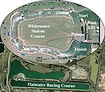
The Penrith Whitewater Stadium is located near Sydney, Australia. It is an artificial whitewater sporting facility which hosted the canoe/kayak slalom events at the 2000 Summer Olympics in Sydney. The facility is part of the Penrith Lakes Scheme, which is converting open-pit sand and gravel mines into lakes for recreation. It is close to Cranebrook and is adjacent to the Sydney International Regatta Centre. These lakes are not filled via the Nepean River, but are filled via rain water and ground water. The operation of the facility aerates the water and improves water quality in the flat water rowing and canoeing course. The course is in the shape of a massive 'U', 320 metres in length, between 0.8 and 1.2 metres deep and between eight and 12 metres wide. The overall drop from top to bottom is 5.5 metres. During events a conveyor belt is used to take boats, and their occupants, from the finishing pool back to the start. As the course has been built in a relatively flat area (flood plain), it has been built up and landscaped to create the sloping course necessary for the required rapids. Five of the six available 300-kilowatt pumps lift the water from the bottom to the start of the course, at the rate of 14 m³/s. The channel is constructed from concrete with sloping sides. By setting river pebbles into the concrete an effect to make the course look like a natural river has been created. Large immovable rocks shape the course, as well as movable obstacles which may be used for varying the difficulty of the course and for fine-tuning of the rapids. The total cost of construction was $AU6 million, of which $1.5 million was paid by Penrith City Council, $1.5 million by the International Canoe Federation (including $300,000 by Australian Canoeing) and $3 million by the Government of New South Wales. The facility, which includes a cafe, is a popular recreational area, offering large rubber raft rides, as well as individual kayaking/canoeing. It is regularly used for local, national and international canoeing/slalom events. It is accessed via McCarthys Lane, which runs off Castlereagh Road, Cranebrook. It served as the host venue for the 2005 ICF Canoe Slalom World Championships. It also hosted the 2014 Junior/U-23 ICF Canoe Slalom World Championships. On 1 July 2023, the NSW Office of Sport took over operation of venue.