Canals of Amsterdam
17th-century establishments in the Dutch RepublicCanals in AmsterdamCanals in the NetherlandsHistory of AmsterdamLists of canals ... and 4 more
Lists of landforms of the NetherlandsTourist attractions in AmsterdamTransport in AmsterdamWorld Heritage Sites in the Netherlands

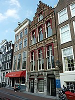
Amsterdam, capital of the Netherlands, has more than 100 kilometers (62 mi) of grachten (canals), about 90 islands and 1,500 bridges. The three main canals (Herengracht, Prinsengracht and Keizersgracht), dug in the 17th century during the Dutch Golden Age, form concentric belts around the city, known as the Grachtengordel. Alongside the main canals are 1550 monumental buildings. The 17th-century canal ring area, including the Prinsengracht, Keizersgracht, Herengracht and Jordaan, were listed as UNESCO World Heritage Site in 2010, contributing to Amsterdam's fame as the "Venice of the North".
Excerpt from the Wikipedia article Canals of Amsterdam (License: CC BY-SA 3.0, Authors, Images).Canals of Amsterdam
Keizersgracht, Amsterdam Centrum
Geographical coordinates (GPS) Address Nearby Places Show on map
Geographical coordinates (GPS)
| Latitude | Longitude |
|---|---|
| N 52.365 ° | E 4.8877777777778 ° |
Address
Keizersgracht 556
1017 EL Amsterdam, Centrum
North Holland, Netherlands
Open on Google Maps


