place

Staincliffe

Geography of BatleyHeavy Woollen DistrictUse British English from August 2020West Yorkshire geography stubs
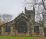
Staincliffe Hall Road, Batley geograph.org.uk 79641

Staincliffe is a cross-over district of both Batley and Dewsbury, in West Yorkshire, England. Historically part of the West Riding of Yorkshire, the name is believed to derive from staine, meaning stone and cliffe, cliff.The area is centred on top of a hill between Dewsbury, Batley and Heckmondwike, north and east of Halifax Road (A638 road) are in Batley (WF17). The section south of Halifax Road, including Dewsbury & District Hospital has a Dewsbury (WF13) postal addresses. Until the 19th century, the hamlet of Staincliffe consisted of Staincliffe Hall (dating from at least the 17th century) a few farms and some 18th-century cottages, many of which survive amongst the later developments. Staincliffe expanded in the 19th century with the growth of the heavy woollen industry. In 1867, a new parish church of Christ Church Staincliffe was consecrated which, along with the vicarage and church school, was designed by William Henry Crossland. Today Staincliffe has many 19th-century houses, but also contains a couple of council housing estates built during the 1950s, as well as a mix of small shops along Halifax Road.

Excerpt from the Wikipedia article Staincliffe (License: CC BY-SA 3.0, Authors, Images).

Staincliffe
Grange Road, Kirklees Staincliffe

Geographical coordinates (GPS) Address Nearby Places
placeShow on map

Wikipedia: StaincliffeContinue reading on Wikipedia

Geographical coordinates (GPS)

Latitude Longitude
N 53.705 ° E -1.647 °
placeShow on map

Address

Grange Road

Grange Road
WF17 7AT Kirklees, Staincliffe
England, United Kingdom
mapOpen on Google Maps

Staincliffe Hall Road, Batley geograph.org.uk 79641
Share experience

Nearby Places

Westborough High School, Dewsbury

Westborough High School is a mixed secondary school located in Westborough, Dewsbury, West Yorkshire, England. It is situated on Oxford Road, and shares its grounds with St John Fisher Catholic High School. The school was founded in the 1960s and has had close links with the other nearby secondary schools. The current (2013) headteacher of Westborough is Jennifer Napper The school admits pupils from the ages of 11–16. Its catchment areas are Ravensthorpe, Savile Town and the local areas of Boothroyd. Over the past 5 years the school's music department, in the new performing arts block at Westborough, has developed a public profile with concerts performed by pupils in the summer and winter. Bands originating at Westborough are the Samba Band and Drumline, which have performed in Batley Park, York and on Sky TV during a rugby match.Westborough High School achieved the third successive year of record rises in GCSE results, with 54% of pupils gaining 5 or more GCSE passes at A* to C, and 34% of these being in English and Maths, a 6% rise on last year, exceeding a 30% target set by the Government.In 2011 Birkdale High School was formally closed, with Westborough High School taking over its site. Some pupils from Birkdale transferred to the Westborough campus immdemiately. However the former Birkdale High School campus was still used to educate a number of pupils under Westborough High School management, and renamed as the Halifax Road Campus. The Halifax Road Campus closed down when the final set of year 11 students finished their GCSEs in 2014.