place

A. B. Miller High School

1991 establishments in CaliforniaEducation in Fontana, CaliforniaEducational institutions established in 1991High schools in San Bernardino County, CaliforniaPublic high schools in California

A. B. Miller High School is one of five high schools in the Fontana Unified School District that services students in the Fontana area of California.

Excerpt from the Wikipedia article A. B. Miller High School (License: CC BY-SA 3.0, Authors).

A. B. Miller High School
Oleander Avenue, Fontana

Geographical coordinates (GPS) Address Website Nearby Places
placeShow on map

Wikipedia: A. B. Miller High SchoolContinue reading on Wikipedia

Geographical coordinates (GPS)

Latitude Longitude
N 34.129444444444 ° E -117.44805555556 °
placeShow on map

Address

A.B. Miller High School

Oleander Avenue 6821
92336 Fontana
California, United States
mapOpen on Google Maps

Website
fusd.net

linkVisit website

Share experience

Nearby Places

Bono's Restaurant and Deli

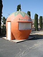
Bono's Restaurant and Deli is a historic restaurant located at 15395 Foothill Boulevard in Fontana, California. The restaurant opened in 1936 to serve travelers on U.S. Route 66, which then passed in front of the site; it originally operated as a produce stand. In 1943, increased traffic on the highway prompted the owners to expand their operations, and the current building was constructed as a full-service restaurant. The restaurant building has a Streamline Moderne design and features red and green stripes promoting its Italian cuisine as well as painted grapevines promoting its wine. As Fontana's Italian immigrant community grew in the 1940s, the restaurant also became a local source of Italian foods previously unavailable in the area.The Big Orange, a 7-foot (2.1 m) tall orange-shaped citrus stand, is located on the property of the restaurant. The orange was originally located 3 miles (4.8 km) to the east; restaurant owner Joe Bono [cousin of Sonny Bono] purchased the stand in the 1990s and moved it to its current site. While the restaurant had an orange-shaped stand of its own when it served Route 66 traffic, it was eventually demolished due to decreased demand. The Big Orange is one of six surviving orange-shaped buildings in California.The restaurant, which reopened on February 8, 2019, after being closed for many years, was added to the National Register of Historic Places in 2008. Joe Bono received permission to move the building 20 feet (6.1 m) back from Foothill Boulevard in 2013.

Rialto Municipal Airport

Rialto Municipal Airport (FAA LID: L67), originally Miro Field, was a general aviation airport three miles (5 km) northwest of Rialto, in San Bernardino County, California, United States. It was used by private aircraft; no airlines flew into this airport. It was about 12 miles northeast of Ontario International Airport and ten miles west of San Bernardino International Airport. The airport did not have a control tower and averaged 82 operations a day. An FBO with a flight school and a separate helicopter flight school operated at the airport. There were several aviation related businesses. Warbirds West Air Museum is relocating its warbird collection to the big hangar at the center of the field. The airport cafe is attached to the WWAM hangar. There was an air ambulance business in the southeast part of the airport. Despite its size compared to nearby airfields (Upland Cable Airport, Corona Municipal Airport, El Monte Municipal Airport, Redlands Municipal Airport and Hemet-Ryan Airport), Rialto was a relatively quiet airport. This led the city of Rialto to approve the closing of the airport by 2009/2010 for redevelopment, driven by real estate developers. The airport was expected to close by January or February 2015, once the San Bernardino County Sheriff's Department Aviation Division relocated to the San Bernardino International Airport. Development of Renaissance Marketplace was planned to begin as soon as the airport closes and the runways are removed. On September 18, 2014, the airport officially closed to air traffic; all runways are marked with yellow Xs.

Auto Club Speedway
Auto Club Speedway

Auto Club Speedway (known as California Speedway before and after 2008–2023 corporate sponsorship from Auto Club) was a 2.000 mi (3.219 km), D-shaped oval superspeedway in unincorporated San Bernardino County, California, near Fontana. It hosted NASCAR racing annually from 1997 until 2023. It was also previously used for open wheel racing events. The racetrack is located 47 mi (76 km) east of Los Angeles and is near the former locations of Ontario Motor Speedway and Riverside International Raceway. The track is owned and operated by NASCAR. The speedway is served by the nearby Interstates 10 and 15 freeways as well as a Metrolink station located behind the backstretch. Construction of the track, on the site of the former Kaiser Steel Mill, began in 1995 and was completed in late 1996. The speedway's main grandstand has a capacity of 68,000, additionally it features 28 skyboxes and has a grand total capacity of 122,000. In 2006, a fanzone was added behind the main grandstand. Lights were added to the speedway in 2004 with the addition of a second annual NASCAR weekend. Since 2011, the track has hosted only one NASCAR weekend each year. A 500-mile American open-wheel car race was held under Championship Auto Racing Teams sanctioning from 1997 to 2002. The current IndyCar sanctioning body ran a 400-mile race from 2002 to 2005 and a 500-mile race from 2012 to 2015, which was usually the season finale. Its last IndyCar race was the 2015 MAVTV 500. In 2023, the track was closed for reconstruction as part of the Next Gen California project. Demolition began in October of that year.