Xiguan Creek
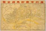
Xiguan Creek (Chinese: 西关涌; pinyin: Xiguān chōng; Jyutping: Sai1gwaan1 cung1) is a former river located in Xiguan, Guangzhou, China. It was about 5 kilometres (3 mi) long and divided into two branches: the Upper Xiguan Creek and the Lower Xiguan Creek. Because of urban development, the waterway has been converted into culverts. During the reign of the Ming Dynasty Wanli Emperor (1572–1620), ships could sail along Xiguan Creek up to the Qingyun Bridge, which is today's Qingyun Li, Taoshadang, and Wanzhong Li. Since the time of the Qing Dynasty, Daguan River, which is connected to Xiguan Creek, has silted up as far as Guilan (called Ruixing Li today). In 1810, Qingyun Li, Taoshadang, and Wanzhong Li were reclaimed. Daguan River ends at 14-Pu Pier, at today's Tu Di Gong Temple in Ruixing Li. According to Nanhaixian Zhi (1872), Ruixing Li had become land by siltation, and Daguan River reached only to Guangya Li. By 1954 only the waterway to the west of Niuru Bridge remained.
Excerpt from the Wikipedia article Xiguan Creek (License: CC BY-SA 3.0, Authors, Images).Xiguan Creek
Shibafu North Road, Liwan District 华林街道
Geographical coordinates (GPS) Address Nearby Places Show on map
 Continue reading on Wikipedia
 Geographical coordinates (GPS)
| Latitude | Longitude |
|---|---|
| N 23.1148 ° | E 113.2409 ° |
Address
十八甫北路
Shibafu North Road
510140 Liwan District, 华林街道
Guangdong Province, China
Open on Google Maps