place

Most SNP

20th-century architecture in SlovakiaBridges completed in 1972Bridges in BratislavaBridges over the DanubeCable-stayed bridges in Slovakia
Inclined towersObservation towers in SlovakiaRestaurant towersRestaurants in SlovakiaTransport in Bratislava
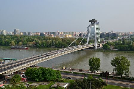
Most SNP, Bratislava (by Pudelek)

Most SNP ("Bridge of the Slovak National Uprising"), commonly referred to as Most Slovenského národného povstania or the UFO Bridge, and named Nový most ("New Bridge") from 1993 to 2012, is a road bridge over the Danube in Bratislava, the capital of Slovakia. It is the world's longest bridge to have one pylon and one cable-stayed plane. Most SNP is an asymmetrical cable-stayed bridge with a main span length of 303 m (994 ft), a total length of 430.8 m (1,413 ft), a width of 21 m (69 ft), and a weight of 537 t (592 short tons). Its steel construction is suspended from steel cables, connected on the Petržalka side to two pillars. There are four lanes for motor traffic on the upper level and lanes for bicycles and pedestrians on the lower level. It is a member of The World Federation of Great Towers.

Excerpt from the Wikipedia article Most SNP (License: CC BY-SA 3.0, Authors, Images).

Most SNP
Bridge of the Slovak National Uprising, Bratislava Dvory (District of Bratislava V)

Geographical coordinates (GPS) Address External links Nearby Places
placeShow on map

Wikipedia: Most SNPContinue reading on Wikipedia

Geographical coordinates (GPS)

Latitude Longitude
N 48.1384 ° E 17.104581 °
placeShow on map

Address

Most SNP (Most cestný;Most Slovenského národného povstania;UFO Bridge;Nový most)

Bridge of the Slovak National Uprising
851 01 Bratislava, Dvory (District of Bratislava V)
Region of Bratislava, Slovakia
mapOpen on Google Maps

linkWikiData (Q837291)
linkOpenStreetMap (238810163)

Most SNP, Bratislava (by Pudelek)
Share experience

Nearby Places

Podhradie, Bratislava

Podhradie (Latin: Suburbium; German: Schlossgrund; Hungarian: Pozsony-Várallya) is a historical part of Bratislava, the capital of Slovakia, situated around the Bratislava Castle hill. Today, it consists of the areas of Zuckermandel, Vydrica and the area above Židovská Street. Until the 13th century, Podhradie consisted of various settlements situated around the castle, outside of the Bratislava city walls with all land on the castle hill belonging to the castle. Zuckermandel and Vydrica were incorporated in 1848 as the 4. district of the city of Bratislava and from 1850 until its partial demolition in the half of 20th century it was called Mesto Márie Terézie (German: Theresienstadt; Hungarian: Terézváros).Podhradie was considered to be the most beautiful and picturesque part of the city, traditionally inhabited by the city poor, it was known especially for its inns and prostitution. Most parts of Podhradie were demolished in the 1950s and 1960s due to the construction of transport infrastructure on the Danube riverbank, including the New Bridge. Today, Zuckermandel is being re-developed with mixed residential/commercial buildings, as of 2017 the demolished Vydrica is for sale and the area above Židovská Street is stabilized, with no new large scale construction planned. Podhradie contains notable landmarks, including ruins of the Water Tower from 1254, St. Nicholas' Church from 1661, Holy Trinity Church from 1738, House of the Good Shepherd from 1765 and it is home to the Museum of Clocks (part of the Bratislava City Museum), Archeological Museum, Music Museum, Museum of Jewish Culture, Museum of Carpathian German Culture and Museum of Hungarian Culture in Slovakia (all part of the Slovak National Museum).