place

Goonhilly Satellite Earth Station

1962 establishments in EnglandBritish Telecom buildings and structuresBuildings and structures in CornwallEarth stations in EnglandIndustrial archaeological sites in Cornwall
Mass media in CornwallScience and technology in CornwallTransatlantic telecommunicationsUse British English from January 2014
Goonhilly2
Goonhilly2

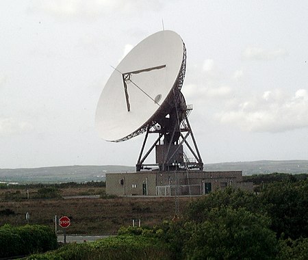
Goonhilly Satellite Earth Station is a large radiocommunication site located on Goonhilly Downs near Helston on the Lizard peninsula in Cornwall, England. Owned by Goonhilly Earth Station Ltd under a 999-year lease from BT Group plc, it was at one time the largest satellite earth station in the world, with more than 30 communication antennas and dishes in use. The site also links into undersea cable lines.

Excerpt from the Wikipedia article Goonhilly Satellite Earth Station (License: CC BY-SA 3.0, Authors, Images).

Goonhilly Satellite Earth Station
B3293,

Geographical coordinates (GPS) Address Nearby Places
placeShow on map

Wikipedia: Goonhilly Satellite Earth StationContinue reading on Wikipedia

Geographical coordinates (GPS)

Latitude Longitude
N 50.048055555556 ° E -5.1819444444444 °
placeShow on map

Address

Goonhilly Satellite Earth Station

B3293
TR12 6RJ , Mawgan-in-Meneage
England, United Kingdom
mapOpen on Google Maps

Goonhilly2
Goonhilly2
Share experience

Nearby Places

Halliggye Fogou
Halliggye Fogou

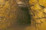
Halliggye Fogou is one of many fogous in Cornwall, England, United Kingdom. The site is under the guardianship of English Heritage, and managed by the Trelowarren Estate, where the fogou is located. Entry to the fogou is free but there is a charge to enter the rest of the Trelowarren Estate.The Halliggye Fogou consists of a long narrow tunnel leading to three sectioned chambers. A window-like entrance which was dug in Victorian times by supposed treasure hunters has since been filled in. The complex of passages has a roof and walls of stone, and is the largest and best-preserved of several mysterious tunnels associated with Cornish Iron Age settlements.It was described by Sir Richard Vyvyan in his "Account of the ‘fogou’ or cave at Halligey, Trelowarren", in the Journal of the Royal Institution of Cornwall (1885, viii. 256–58) In 1861, J. T. Blight wrote a comprehensive description and drafted plans of the fogou in conjunction with Sir Richard Vyvyan, the landowner who listed finds as a vase containing ashes and a roughly made cup, both of Celtic manufacture, and animal bones possibly from a deer.In the 1980s, a series of small excavations were carried out by English Heritage mainly to clear debris from the passage to aid examination and repair work after routine ploughing of the field, when the blade of the plough breached the roof of the main chamber: this hole has since been turned into an entrance stairway for visitors. Pottery found during excavations has included local Iron Age cordoned wares and some sherds of Roman Samian ware from southern Gaul.It was used during the Second World War by the Manaccan Auxiliary Unit as an explosives and ammunition store.

Meneage
Meneage

The Meneage (Cornish: Menaghek or Manahek) is a district in west Cornwall, United Kingdom. The nearest large towns are Falmouth and Helston. (Note: the coordinates above are the approximate centre of the Meneage district.) The meaning of the name Meneage is "Monkish (land)" and the probability is that in the post-Roman period the land was in the possession of a confederacy of small Celtic monasteries. These may have been founded by missionaries from Brittany. "The north-eastern half of the Lizard peninsula ... has, for the last 1000 years at least and probably for a considerable time longer, gone by the popular name of Meneage, pronounced Menāgue. This name, like Roseland, has no official significance."—Gilbert H. Doble.The Meneage district is located south of the Helford River and is divided into four parishes and part of a fifth. From west to east these are St Mawgan in Meneage (part), St Martin in Meneage, Manaccan, St Anthony in Meneage, and St Keverne. St Mawgan in Meneage. The church is dedicated to St Mauganus; St Martin's is a chapelry belonging to this parish. Part of the parish is not in the Meneage district. St Martin in Meneage. The church is dedicated to St Martin of Tours and is a chapelry of Mawgan in Meneage (right of sepulture was granted in 1385). The ancient estates of Barry Mylor and Mathiana adjoin the church and the two names indicate that in early times there were chapels of two Breton saints here. Of St Melor at Merther Mylor (Barry Mylor) and St Anou at Merther Anou; the modern forms being variously corrupted. Manaccan. Though St Manacca was recorded as the patron saint in 1308 it is probable that the name has the meaning of Monks' Church. The form of the dedication in use today is to St Manaccus and St Dunstan. St Anthony-in-Meneage. The village is at OS Grid ref SW782256. The church is dedicated to St Anthony and is somewhat away from the village near Gillan Harbour. St Keverne. The monastery here remained in existence after the Norman Conquest but subsequently fell into the hands of a layman. The church is dedicated to St Akeveranus. In the parish is Lesneague which can be derived from Cornish lis (court) and manahec (monks' land) which would indicate that it was once the seat of a local chieftain.